Ancient Civilizations and Geology of the Eastern Mediterranean
William Revell Phillips
Wm. Revell Phillips, “Ancient Civilizations and Geology of the Eastern Mediterranean,” in Excavations at Seila, Egypt, ed. C. Wilfred Griggs, (Provo, Utah: Religious Studies Center, Brigham Young University, 1988), 1–18.
Wm. Revell Phillips was professor of geology at Brigham Young University when this was published.
The Geologic History
World climate zones are a consequence of persistent cyclic currents in the atmosphere of the earth and have persisted throughout at least the later eras of geologic time. Air warmed by the sun rises near the earth’s equator to form the equatorial low and is cooled in the upper troposphere, causing its water content to condense as torrential rains. This warm-humid zone forms a jungle belt about 30 degrees broad centered on the equator. North of this humid jungle zone, winds blow south to the equatorial low from the high pressure at the horse latitudes (30 degrees -35 degrees). These trade winds blow to the southwest (coriolis effect) and are warmed as they approach the equatorial regions. Warming increases the ability of the air to hold moisture and little rain falls between 15 degrees and 35 degrees north (or south) latitude so that desert zones flank the equatorial jungles. Between the horse latitude high (30 degrees—35 degrees) and the subpolar low (60 degrees) the prevailing westerlies blow to the northeast and cool as they approach the polar regions. This temperate climate zone, characterized by periodic, widely distributed rainfall controlled by local topographic features, forms the major agricultural regions of the world, and accommodates most of the world’s population.
In the early Mesozoic (c. 200 MYBP) the continental masses of the earth appear to have been clustered as a single land mass (Pangea), largely in the southern hemisphere. A large arm of the single ocean nearly divided a northern land mass (Laurasia) from a southern one (Gondwanaland) as an east-west sea (Tethys Sea) open to the east. Throughout the Mesozoic era the land masses appear to have moved northward; and the Mesozoic sediments of Europe, Asia and North America which began in the humid coal swamps of a tropical jungle and ended in the massive crossbedded sands of a vast desert, indicating the passage of the northern continents through the climate zones described above. The earliest Mesozoic sediments on parts of Africa, South America, India and Australia are of glacial origin, suggesting a cluster of these continents near the south pole.
A plate subduction zone along the northern edge of the Tethys Sea consumed the ocean crust of the Tethys beneath the Laurasian land mass as the southern land mass moved rapidly northward. Small land masses (e.g. Anatolia, Iran, Tibet) riding on the subducting plate impacted on the southern edge of Laurasia, folding on their northern edge the sediments deposited on the continental slopes of Laurasia, and active subduction moved south of these land masses which were now sutured to the northern continent.
In the late Mesozoic (c. 100 MYBP), continental rifting separated the Americas from Europe and Africa and the first ocean crust of the new Atlantic ocean formed along the mid-Atlantic rift. Africa continued its northeast movement against the southern edge of the Eurasian continent further closing the Tethys Sea. A small Italian plate, either as an independent microcontinent or as a northern peninsula on the African plate, impacted against the southern edge of Europe, folding the Tethys sediments and ocean crust into a high mountain range (Alps) and swinging counterclockwise toward the Dalmatian coast (fig. 1).
About 50 MYBP (Early Eocene) the Red Sea rift began to open as the Arabian plate swung counterclockwise away from Africa to impact on the southern edge of Asia, closing the old Tethys on the east and forming the Zagros Mountain chain between Arabia and the Iranian Plateau.
The Mediterranean Sea, as a remnant of the ancient Tethys, was closed on both east and west and diminished by evaporation in the arid climate of the desert climate zone. By late Miocene (c. 10 MYBP) the Mediterranean basin was separated into an eastern and western basin by a ridge from the Atlas Mountains through Sicily to the Italian Peninsula. The western basin evaporated to complete dryness, depositing great thicknesses of salt in the Balearic Sea, and the eastern basin contained little more than an isolated saline lake thousands of feet below sea level. The major rivers cut huge, Grand Canyon-like gorges into the sub-sea level Mediterranean basins. The Rhone River was the only major river emptying into the western basin but, in the eastern basin, the Nile emptied waters from the equatorial jungles and, through the Dardanelles and Bosphorous, waters poured from the Black Sea and the rivers of Central Europe and Russia. By early Pliocene (c. 5 MYBP) the Atlantic broke into the arid Mediterranean basin through the Gibraltar Strait and the world’s greatest waterfall must have been spectacular for a thousand years as the Mediterranean basin filled to the prevailing sea level. The huge river canyons were flooded and Pliocene sediments were deposited in the Nile gulf and the embayments formed by the other major rivers. The Nile and Rhone refilled their valleys with sediment from the African jungles and western Europe; however, the Dardanelles-Bosphorous still remains a deep waterway allowing the access of deep-water shipping to the Black Sea, perhaps because the Black Sea acts as a catch basin for river sediments, and the short stretch of river from the Black Sea to the Mediterranean carries little sediment.
The level of the Mediterranean was subject to the rise and fall of worldwide sea level with the cyclic growth and decline of continental glaciers throughout the Pleistocene and, at times, may have fallen below its Gibraltar outlet and evaporated to levels below that of the major oceans. In response to their changing base level, the major rivers repeatedly scoured and refilled their channels.
The Present Geologic Status
The Mediterranean region is one of the more complex geological areas on earth and appears as a junction of many plate boundaries and a hodge podge of several ill-defined small plates between the two large plates of Eurasia and Africa. The plate boundaries in the Mediterranean are in need of considerable refinement; however, a general picture will be attempted here (fig. 1).
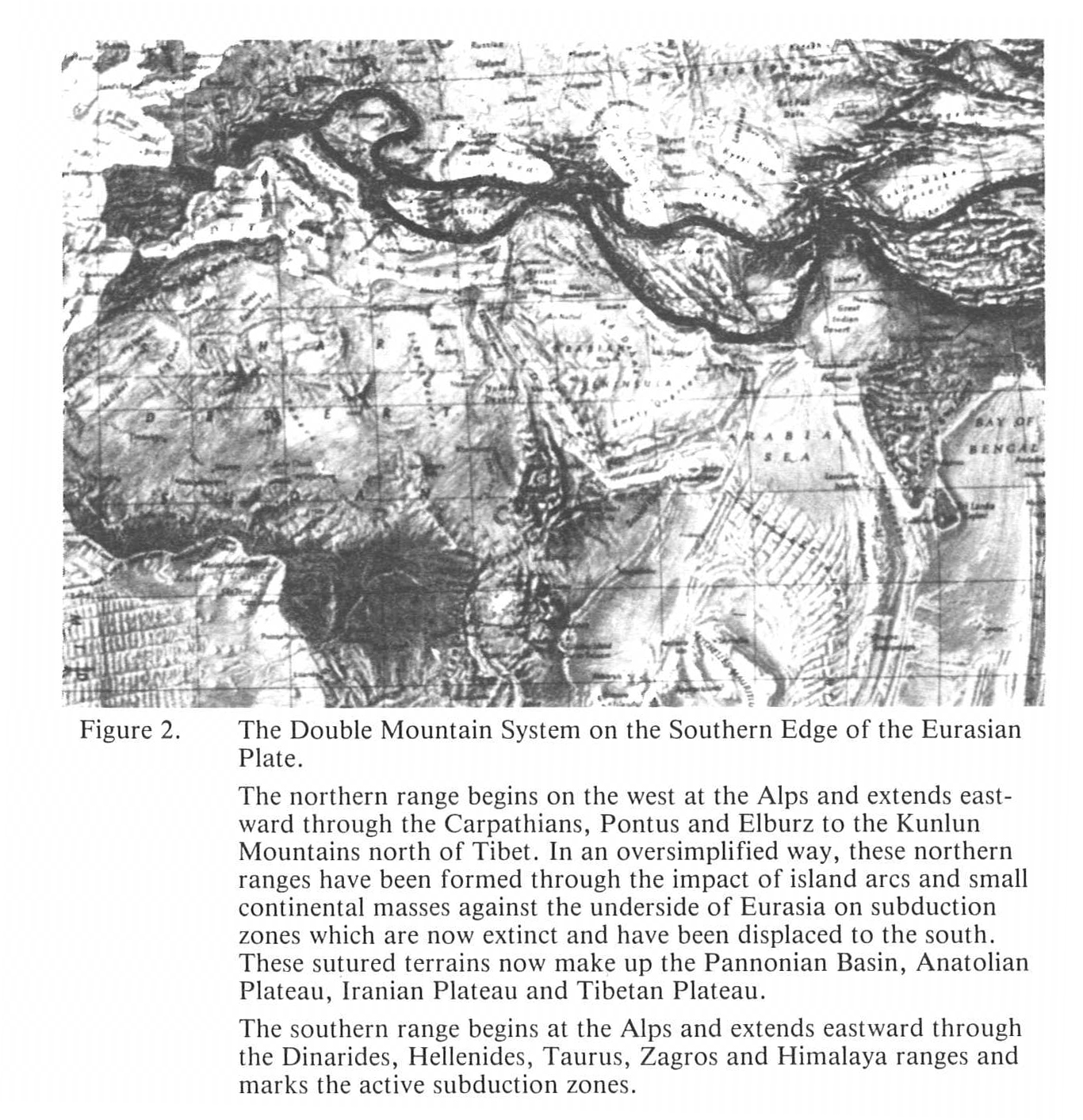
The writer proposes an active Italian plate, Aegean plate and Turkish plate between the larger Eurasian and African plates. To the east, an Arabian plate is swinging counterclockwise away from Africa and impacting against Iran; and the Indian subcontinent is attempting to underride the Tibetan Plateau on a dying subduction zone. A double mountain system (fig. 2) from the Alps through the Himalayas suggests the impact of small land masses along much of the south Eurasian margin and their suturing to the Eurasian underside on extinct subduction margins. These sutured land masses are logically represented by the Pannonian Basin of Yugoslavia, the Anatolian Plateau in Turkey and the Iranian and Tibetan Plateaus to the east. An inland chain of mountain ranges mark the suture zones from the Carpatheans, north of the Pannonian Basin to the Kunlun Mountains north of Tibet, with the Pontus and Elburz Ranges marking the northern edges of the Anatolian and Iranian Plateaus, respectively. The southern margin of these sutured land masses is marked by an active mountain chain beginning in the west, with subduction zone mountains in the Dinarides, Hellenides and Taurus, and ending in the east with the continental impact mountains in the Zagros and Himalayas.
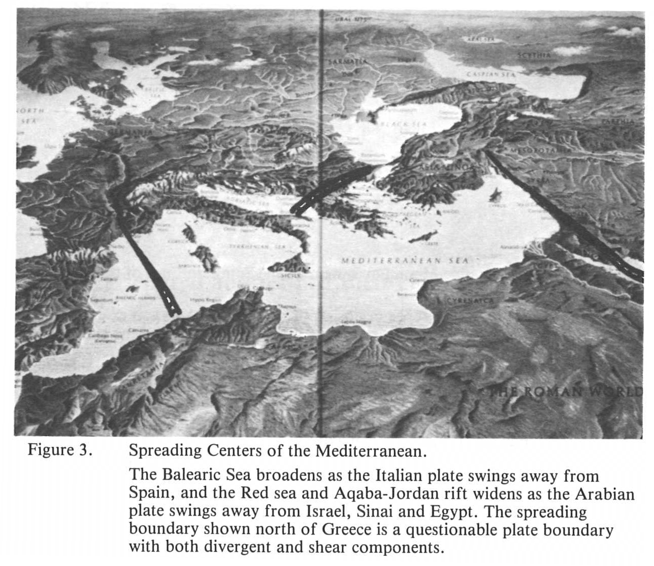
Active divergent plate boundaries, i.e., spreading centers (fig. 3), appear to exist in the Balearic Sea, on the west edge of the Italian plate; in Northern Greece, on the north edge of the Aegean plate; and in the Red Sea where the rift extends northward through the Gulf of Aqaba to the unique Dead Sea-Jordan Valley.
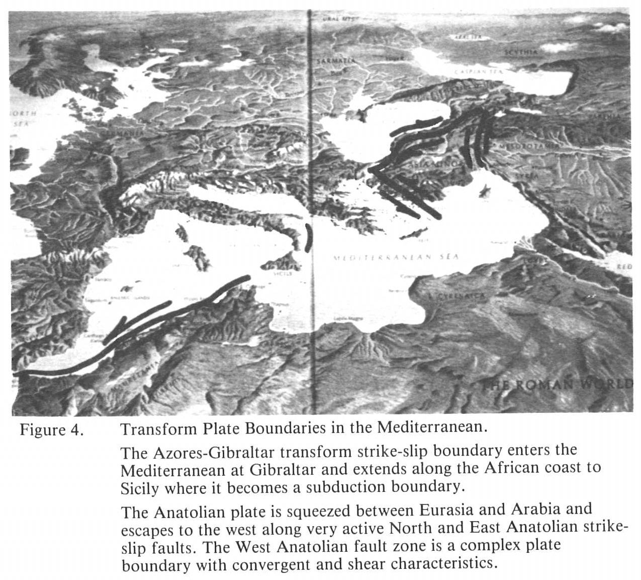
Strike-slip, transform boundaries (fig. 4) are represented by the Azores-Gibraltar ridge which enters the Mediterranean through the Strait and extends along the North African coast to the Atlas Mountains. The Turkish plate is squeezed westward along the North Anatolian and East Anatolian transform faults to contact the Aegean plate along the West Anatolian fault zone, a boundary of questionable nature.
Convergent plate boundaries, i.e., subduction zones (fig. 5), are marked by colliding land masses and interior mountain ranges at the Alps, on the north of the Italian plate, and at the Zagros Mountains, on the Arabian-Asian suture. Active subduction trenches exist at the Calabrian trench south of Sicily and the Italian foot, and at the Hellenic trench arcing from the Italian heel south of Greece and Crete, across the southern edge of the Aegean Sea into the Mediterranean south of Turkey to the East Anatolian fault. Cyprus appears to be a wedge of sea floor between branches of the subduction arc. The vulcanism and the Apennines of the Italian peninsula are best explained by a subduction boundary against the eastern edge of the Italian peninsula in the Adriatic Sea.
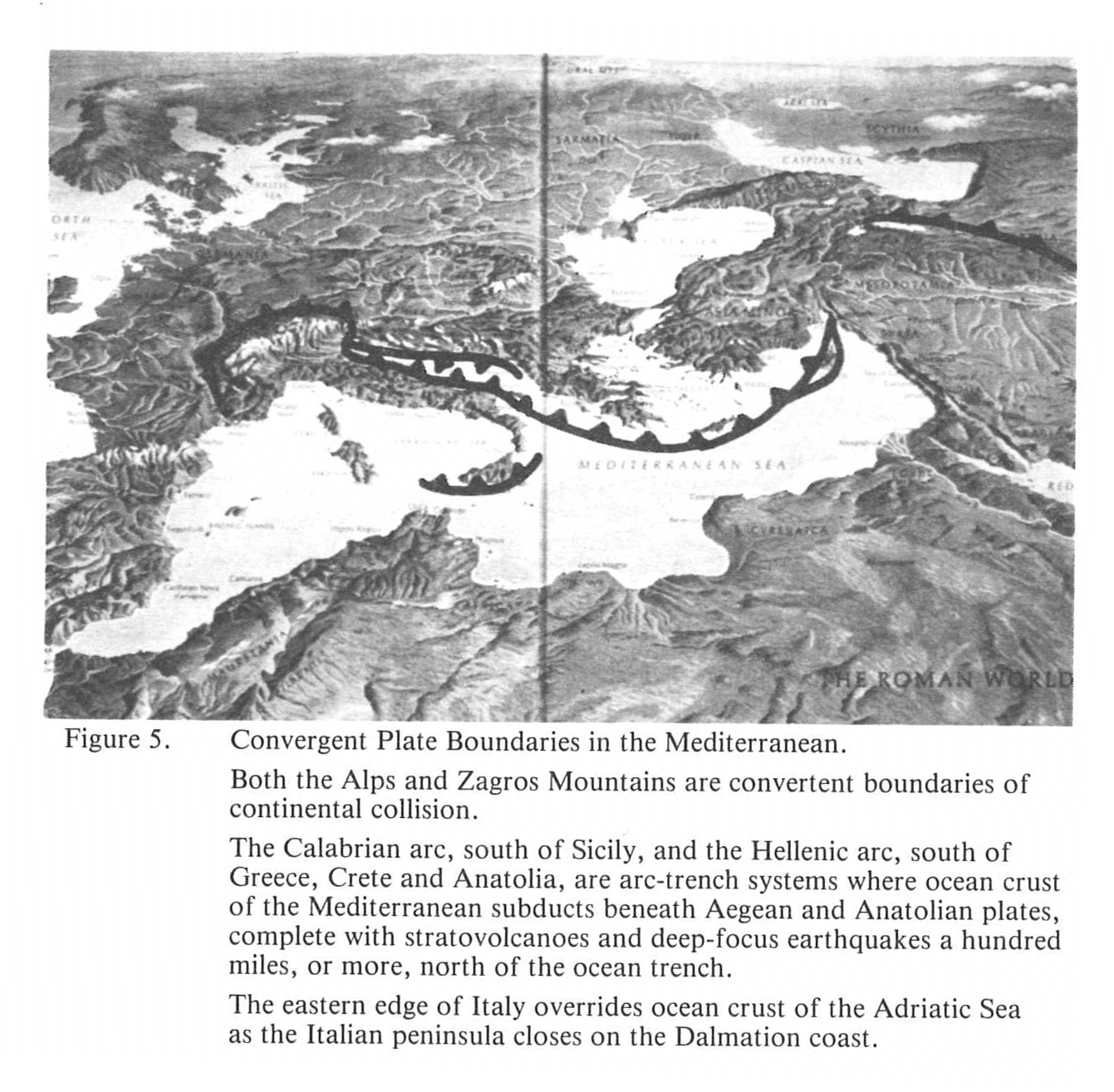
Plate motion (Fig. 1), described by reference to a fixed Eurasian plate, shows the African plate moving northeast, subducting what little ocean crust remains beneath Greece and Turkey at the Hellenic Arc. The Arabian plate is also moving northeast at an even faster rate, impacting against Iran and rotating counterclockwise away from the African plate along the Red Sea-Jordan Valley rift. The wedge-shaped Turkish plate is moving west on the North and East Anatolian transform faults, as it is squeezed between the Arabian and Eurasian plates and is bumping the Aegean plate which is moving southwest as the overriding plate at the Hellenic Arc. The Italian plate impacting the Eurasian plate at the Alps is swinging counterclockwise over a subduction zone in the Adriatic Sea closing the Adriatic against the Dalmatian coast and enlarging the Balearic Sea to the west.
Geology and the Cultural Development of the Mediterranean
The ancient peoples of western civilization saw the Mediterranean region as the whole of the civilized world and regarded those little known peoples beyond their world as barbarians. Those who inhabited the Mediterranean shores were isolated by geological phenomena. North of the sea were high mountain ranges diverting major rivers away from the Mediterranean and acting as a barrier to migrations and interaction with the peoples of central and northern Europe. South of the sea was a broad impenetrable desert separating the Mediterranean from the cultures of central Africa. The peoples of the Mediterranean formed prosperous seafaring kingdoms, by necessity, and the sea became a broad highway of trade and commerce. Few windows in the self-sufficient, isolated Mediterranean led to the outside world. Beyond the Pillars of Hercules was the vast, open ocean and an occasional contact with the British Isles and the Nordic people. The largest window was at the east end of the sea where the Euphrates and Tigris Rivers led through the fertile Mesopotamian Valley to the Persian Gulf and the fabled orient. Strong kingdoms in Mesopotamia and the Iranian Plateau repeatedly repelled the armies of the Mediterranean empires, effectively closing the eastern window. Alexander the Great briefly opened the eastern window which also accommodated forays from the east by Mongols, Tartars and Turks.
The Rhone Valley opened into barbaric Gaul; the Nile led to the jungles of east central Africa and cultures of little consequence; and another window opened to the north through the Dardanelles and Bosphorous into the Black Sea and subsequently to the Danube, Don, Dneiper and other river highways of eastern Europe and the steppes of Russia. These highways may have brought Nordic Hittites from Baltic regions and, in post Christian times, they introduced the princes of Russia to the grandeur of Byzantium and the orthodoxy of the eastern church.
Coastlines and harbors are of vital concern to seafaring people and the choice of harbors often foretold the destiny of cities and empires. The southern coasts of the Mediterranean are largely fronted by deserts and drifting sand. Good, protected harbors like those at Carthage were rare indeed, and the coastlines of Libya and Egypt do not have good harbors and are largely uninhabited. Although Alexandria was second only to Rome in the centuries of early Christianity, its harbor is poor and unprotected. Its location on a stabilized off-shore bar on the western tip of the huge fan-type delta of the Nile was wisely chosen by Alexander, since the silt of the Nile distributaries is swept away from the harbor by eastward longshore currents. In recent geologic time, the Nile has introduced sufficient sand and silt into the Mediterranean to build a great delta, of about a 100-mile radius, rounded on the seaward side by the east-moving currents which carry its silt along the coasts of the Sinai and Palestine, producing a straight, sandy coastline. Harbors at Ashdod, Jaffa and Caesarea were man-made with artificial jetties to fend off the advancing sand. Only at Haifa, where Mt. Carmel juts into the sea to defend the Bay of Acre to its north, does Israel have a natural port. North of Haifa the longshore currents have spent their sand, and the highlands on the west edge of the Jordan Valley rift define the coastline. Good harbors begin to appear at Tyre, Beirut and Tripoli.
The entire north coastline of the Mediterranean is mountainous due to active plate subduction or continental collision. The elevated sea level of the world’s interglacial sea produces a submergent coastline on these northern shores with a multitude of islands, headlands, embayments and an abundance of large, protected, deep water harbors. Most major empires of classical antiquity developed on the north Mediterranean shores, and cities like Smyrna, Byzantium, Athens, Corinth, Venice, Naples, Genoa and countless others flourished with the trade and commerce of busy ports. Other major cities, limited by a small harbor, and poorly located at the head of a small embayment fed by a minor river, grew to their zenith and then declined as their inadequate harbors silted in. Thus, city giants of the classical era, like Miletus, Ephesus, Troy and others died as their harbors filled with river silt to become malaria-breeding swamps; and today their ruins lie miles from the sea.
Earthquakes occur along all crustal plate boundaries as a result of separating plates, converging plates or plates grinding past one another. The earthquakes of spreading rifts and transform boundaries are shallow focus; however, those caused by plates plunging into the mantle may be shallow or deep and may create epicenters well within the overriding plate. The Red Sea-Jordan Valley rift produced earthquakes of Biblical significance. The plates containing Asia Minor, Greece, Italy and Iran are small and all of these lands are subject to frequent earthquakes. Southern Italy, Crete, Macedonia, West Anatolia, and North Anatolia are especially seismically active and the margin faults of Iran have repeatedly toppled Persian cities. The stone structures of the Greeks, Romans and others were intolerant of shaking ground. As a result, marble temples were repeatedly destroyed and rebuilt, and toppled marble columns are characteristic of most Hellenistic ruins.
Volcanoes have also directed the course of ancient civilizations and are associated with only certain plate boundaries. Spreading boundaries are usually in the seas and are characterized by fissure eruption of fluid basaltic lavas. Occasional basalt flows along the Jordan Valley suggest the spreading environment.
Large composite volcanoes, or stratovolcanoes, are confined to subduction boundaries and appear in the Mediterranean north of the Calabrian arc, in Sicily and the Lipari Islands; north of the Hellenic arc, in the southern Aegean Sea and southern Anatolia north of the Taurus Mountains; and along the Italian peninsula, especially in the south. The stratovolcanoes are violent and eject more ash and tephra than molten lava, and may explode and collapse to giant calderas.
Perhaps the greatest explosion the earth has known was the eruption of Thera or Santorini, in the south central Aegean about 1500 B.C. The eruption created a huge submarine caldera of which the modern Santorini islands are a mere shell. It covered much of Crete with deep ash and spread ash across the Mediterranean towards Egypt. The eruption of Thera may have destroyed the Minoan civilization on Crete and stimulated waves of refugees to wash ashore on eastern Mediterranean shores as the mysterious “Peoples of the Sea.” Some have even attributed the plagues of Moses to the eruption.
Mt.Vesuvius, on the Bay of Naples, has erupted periodically through historic times since its heralded eruption of AD. 79. The volcano, known as Mt. Somma, must have been dormant for centuries before it exploded to an open caldera in AD. 79, burying the Roman city Pompeii with air-fall ash after smothering many of its inhabitants with gasses and dust. Pliny the Elder and many other prominent Romans died in the rain of ash. Only a few miles away Herculanium was overwhelmed by mud flows mobilized by torrential rains, from the electrical storms capping the eruption, falling on slopes of loose ash and dust. Several subsequent eruptions have built a very substantial volcanic peak, Mt. Vesuvius, within the Somma caldera, and have become less violent with shorter dormant periods. Mt. Etna, on Sicily, has erupted frequently through historic time and the mountain and its sulfur mines are often mentioned in ancient history.
The several volcanic islands of the Lipari group, north of Sicily, were anciently known as the Aeolian Islands and were the legendary home of the winds. Mt. Stromboli was the “lighthouse of the Mediterranean” and its neighbor, Mt. Volcano, was the forge of Vulcan and entrance to the underworld.
The stratovolcanoes of central Anatolia are numerous and active. Ash and dust from Mt. Ergeus, Hasan Dagi and other volcanoes filled the valleys of Cappadocia with volcanic ash which subsequently weathered to the cones, pinnacles and “fairy chimneys” of Cappadocia. In these soft ash cones early Christian groups of Cappadocia and Galatia, possibly founded by the Apostle Paul, cut their chapels, homes and hidden underground cities. It was here they sought refuge from the Iconoclastic persecutions and painted their icons on underground walls and ceilings. Here, also, they hid from marauding armies of Arabs, Mongols, Tartars and Turks.
Wherever there were Romans, there were Roman baths; and, wherever there were convergent or divergent plate boundaries, there were hot springs to feed the baths. We know today that thermal waters bubble up along the central axis of the Red Sea rift depositing valuable metals on the sea floor. In ancient times, hot springs along the northward extension of that rift were the sites of elaborate Roman spas like the famous baths at Hammat Pader. Subduction at the Hellenic arc produced not only volcanoes, but abundant hot springs on the Greek islands and the south coast of Turkey; and the west Anatolian fault zone localized thermal springs and white travertine terraces at Hierapolis (modern Pamukkale—”colton fortress”) where the ruins of ancient baths cap the terraced mounds and modern tourists swim in the thermal waters just as their Roman ancestors did. Hot springs and calcareous spring deposits are also abundantly associated with the vulcanism of the Calabrian arc and the Italian peninsula. Italian travertine was the “stuff of many Roman columns, buildings and highways and is shipped throughout the world today.
Other building materials of ancient societies were, likewise, a consequence of their geological settings. The Mesopotamian Valley, the “land between the rivers,” was a world of mud and clay. Structures were of mud and clay brick. The finest facades of the king’s palace were colorful glazed clay ceramics; and written documents were tablets of clay indented by cuneiform characters.
In Upper Egypt, the Nubian sandstone forms the cliffs flanking the Nile valley, and the monuments of Ramses and the Ptolemaic temples are drab, gray-brown sandstone. The lower Nile cuts Eocene limestones which overlie the Nubian sandstone, and the pyramids are largely soft, tan limestone. In the East Desert, the thermal plateau along the west edge of the Red Sea spreading center has exposed the basement rock of the Arabo-Nubian massif, and there granitic intrusions and metamorphic gneisses were quarried for statues and obelisks. The famous Aswan granite was barged down the Nile to the sea and thence to all parts of the Mediterranean world.
Along the northern Mediterranean coast are the igneous and metamorphic rocks distinctive of subduction zones. The north shore sediments of the old Tethys Sea were largely limestones and their metamorphism yielded marble, the favorite building stone of the Hellenistic period. Marbles were often brecciated by subduction, and the temples, baths, theaters and other public buildings of ancient agoras often contained slabs or columns of brecciated and recrystallized marble. Green serpentine rock, often brecciated, is also common in Greco-Roman structures. It is part of the ophiolite suite which consists of basaltic pillow lavas and peridotites (largely altered to massive serpentine) with accompanying deep-water limestone and chert. Ophiolite rocks are said to represent ocean crust “scraped” onto the overriding plate at subduction trenches.
Metals commonly defined the progressive stages of ancient civilizations. The Copper Age drew heavily from the island of Cyprus, which means “copper,” and which is a copper-rich wedge of ocean crust between branches of the Hellenic trench. Egypt mined copper in the central Sinai, and King Solomon’s mines in the Wadi Araba supplied copper, bronze and brass for the temple at Jerusalem. Other plate boundaries, both modern and ancient, supplied copper, especially those surrounding Asia Minor which was perhaps the most blessed of all the ancient world with mineral resources. Native copper was used directly; and the ancients quickly learned to reduce the metal from oxides and carbonate ores.
The Bronze Age required the addition of tin which was not common in the Mediterranean region. Minor tin occurred in the Pontus Mountains near the copper deposits at Erzincan in northeast Asia Minor. Mariners brought tin from Spain and ventured beyond into the vast Atlantic to reach the major source at Cornwall, England. Brass, too, was an ancient alloy probably resulting from the accidental smelting of copper ores with naturally associated calamine or smithsonite (i.e.,silicate and carbonate and zinc).
Gold has long been the measure of wealth and has financed the expansion of empires and the luxury of royal courts. It was found as a malleable native metal by patient searchers and molded into offerings to gods and kings. Thermal plateaus on both sides of the Red Sea spreading center expose the granitic intrusions of continental shield rocks, and from this basement complex comes gold. In Egypt, placer gold washed west from the East Desert plateau into the wadis, the Nile and east into the Red Sea wadis. Somewhere east of the Red Sea, wadis also yielded gold in the fabled lands of Ophir and Sheba.
Philip II of Macedonia mined gold from Mt. Pangaion on the spreading plate boundary north of the Aegean plate and, with it, he and his famous son Alexander financed their Macedonian armies which conquered the “world.”
Numerous localities in Asia Minor produced gold, and the Greeks told tales of great wealth beyond their domain. King Midas of Phrygia, who ruled from Gordium in central Anatolia and who turned to gold all that he touched, bathed in the Sangarius River which in turn carried gold to Lydia to supply the riches of King Croesus. Lydia was, indeed, the first kingdom to mint gold coins in the sixth century B.C. Jason pursued the golden fleece in the Pontus Mountains of north Anatolia, and other Greek heros returned with riches from Asia Minor.
Silver seemed equally as rare as gold and was largely a product of the mountains and massifs of Asia Minor. Mines near ancient Ephesus supplied silver for the souvenir figures of Diana fashioned by Demetrius and for the silversmiths who threatened the Apostle Paul (Acts 19).
Egypt—the Ideal Land of Antiquity
Each of the ancient civilizations inhabited a site of geographic and geological advantage, but none could surpass the natural advantages of the Nile valley.
(1) Broad, impenetrable deserts flanked the Nile valley to the east and west protecting Egypt from even the most daring invaders. Up river, the Nubian tribes could usually be discouraged by Egypt’s awesome reputation symbolized by a colossus of Ramses at Abu Simbel. Down river, the Nile delta exposed a 150 km shoreline to the open Mediterranean, vulnerable to invasion from the sea. Most invading armies, however, followed the natural highway across the northern Sinai so the Egyptian army had to defend a frontier less than 100 km long, between the Mediterranean and the Gulf of Suez, against troops which would have been exhausted by a long desert trek.
(2) The Nile River and its delta distributaries formed the ideal highway system which brought commerce to within a few kilometers of every habitable site in Egypt. The smooth flowing river carried ships and barges northward with its gentle current; and south-bound vessels needed only to raise their sails to catch the northeast trade winds which urged them slowly upstream.
(3) The Nile brought an abundant and dependable supply of water from the tropical rain forests where the rains never failed. While other Middle East and North African nations struggled through periods of drought and famine, Egypt enjoyed blue skies and resourcefully managed its unfailing, unique supply of water. The children of Israel were not the only people to leave a famine-stricken land to seek refuge in the land of the Pharaohs.
(4) Annual floods renewed soil fertility with silt from the African rift and filled countless reservoirs with irrigation water for the coming dry season. For thousands of years, until the building of the Aswan dam, Egyptian farmland remained fertile and during the Roman era was the “breadbasket” of the empire. The flood season also forced peasants from their land onto the desert where Pharaohs organized public-works projects that would ensure their place in history.
(5) The mild climate of the Nile valley and delta was dry, warm and healthful, requiring minimum protection from the atmospheric elements. Rains were rare and winds were seasonal and little more than annoying to inhabitants of the long, narrow empire. Although the Nile valley follows a major fault system which has been somewhat active in historic times, and Miocene volcanic flows were extensive on the western plateaus, Egypt was relatively free of the threat of major earthquakes and volcanoes. Plate boundaries were at least as far away as the Red Sea and the northern Mediterranean and everyday life was secure and easy in Egypt.
(6) The long Nile valley was the only migration highway from the jungles of central Africa to the Mediterranean. Animals from the jungle, huge flocks of water birds and schools of fish moved along the river. Hunting and fishing were good and gave variety and protein to a diet already rich from the produce of an ever-fertile farmland.
The Fayum
In the land of Egypt, which has been repeatedly described as unique, the Fayum valley has its own uniqueness. It is the largest oasis of the west desert (c. 12,000 sq km), a sub-sea level depression separated from the Nile valley by only a few kilometers of desert, partly occupied by a freshwater lake and the only major farmland outside of the Nile valley and delta. Springs discharge clear, pure groundwater, undoubtedly from the influent Nile River, into the depression.
In Paleolithic time the Nile-Fayum divide was breached by a distributary of the Nile and the Fayum depression formed a lake and marshland (Lake Moeris) inhabited by flocks of birds and surrounded by camps of Neolithic hunters. Amenemhat I of the 12th Dynasty (c. 1800 B.c.) took control of the Fayum by constructing earthwork dams at the Nile-Fayum breach. When the Nile was high, he flooded the depression where he held water for the dry season to be released for irrigation on the lower Nile valley and delta. Through the Pharaonic period the Fayum often languished as swampland between periods of useful water storage.
Greek culture came to Egypt with Alexander in 333 B.C. and thrived under the Ptolemies. About 300 B.C. Ptolemy II (Philadelphus) reclaimed the Fayum valley for agriculture, and Lake Moeris was confined to the present bounds of Birket el-Qarun which lies at the northwest corner of the depression. It measures about 40 km x 10 km and is 45 m below sea level. The Fayum still receives water from the Nile through the Bahr Yusef Canal and is irrigated by a complex network of canals which terminate in the lake. Although the canals drain a highly saline region and the lake lies below sea level with no apparent outlet, the remarkable Birket el-Qarun is only slightly brackish with 1.3% salt content compared to the Mediterranean with more than 3.5% salt.
Ptolemy II constructed cities at several sites in the Fayum, including Karanis, Philadelphia, Bacchias, Philoteris, Dionysias and others, bringing Greek culture and religion there. Julius Caesar, in pursuit of Pompeii, absorbed Egypt into the Roman Empire, and for many centuries the isolated Fayum and its beautiful lake became the vacation retreat and playground of Roman Emperors and their friends.
Christianity came to Egypt very early, and during the second and third centuries Alexandria was a major center of Christian activities and religious study. Controversial Christian leaders and “heretical” Christian sects found a home at Alexandria, and their doctrines flourished in isolated communities throughout Egypt until the Arab conquest. The Fayum communities showed uncommon resistance to Islam and even today retain an unusually large Christian population.
Excavations of the Seila archaeological expedition were begun in February 1981 at Fag el-Gamous on the east edge of the Fayum depression, as a joint venture of the University of California at Berkeley and Brigham Young University. They were continued in February and March 1984 by BYU. They give tantalizing glimpses of a fair-haired Christian community whose doctrines and traditions remain hidden in the sands of the eastern Fayum.
