Potential for Geologic and Interdisciplinary Research in and around the Fayum Depression in Egypt
J. Keith Rigby
J. Keith Rigby, “Potential for Geologic and Interdisciplinary Research in and around the Fayum Depression in Egypt,” in Excavations at Seila, Egypt, ed. C. Wilfred Griggs, (Provo, Utah: Religious Studies Center, Brigham Young University, 1988), 19–30.
J. Keith Rigby was professor of geology at Brigham Young University when this was published.
Introduction
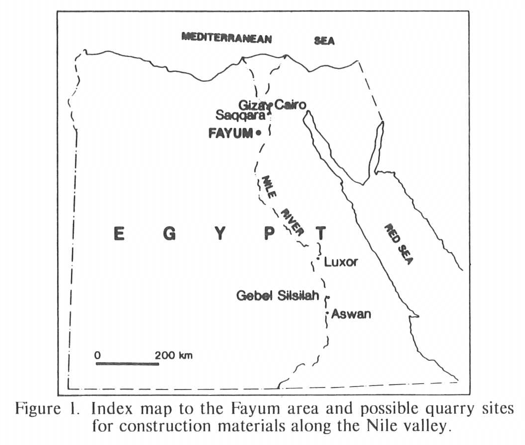
Even a short visit to the Nile valley and Fayum areas in the Western Desert of Egypt is enough to show the great potential of these areas for research in many disciplines. Let me use geologic research as an example. Much remains to be discovered of the geologic structure and stratigraphy of the area, geologic history, paleontology and details of geomorphic development and their influences on man, from Paleolithic to modern times. The potential for interdisciplinary study is particularly promising in areas where archaeological, geological, botanical, and other scientific research can be integrated. Initial archaeological and geological investigations have been undertaken by the Brigham Young University team in the eastern part of the Fayum depression (fig. 1) near Seila from 1981 through the 1984 field season.
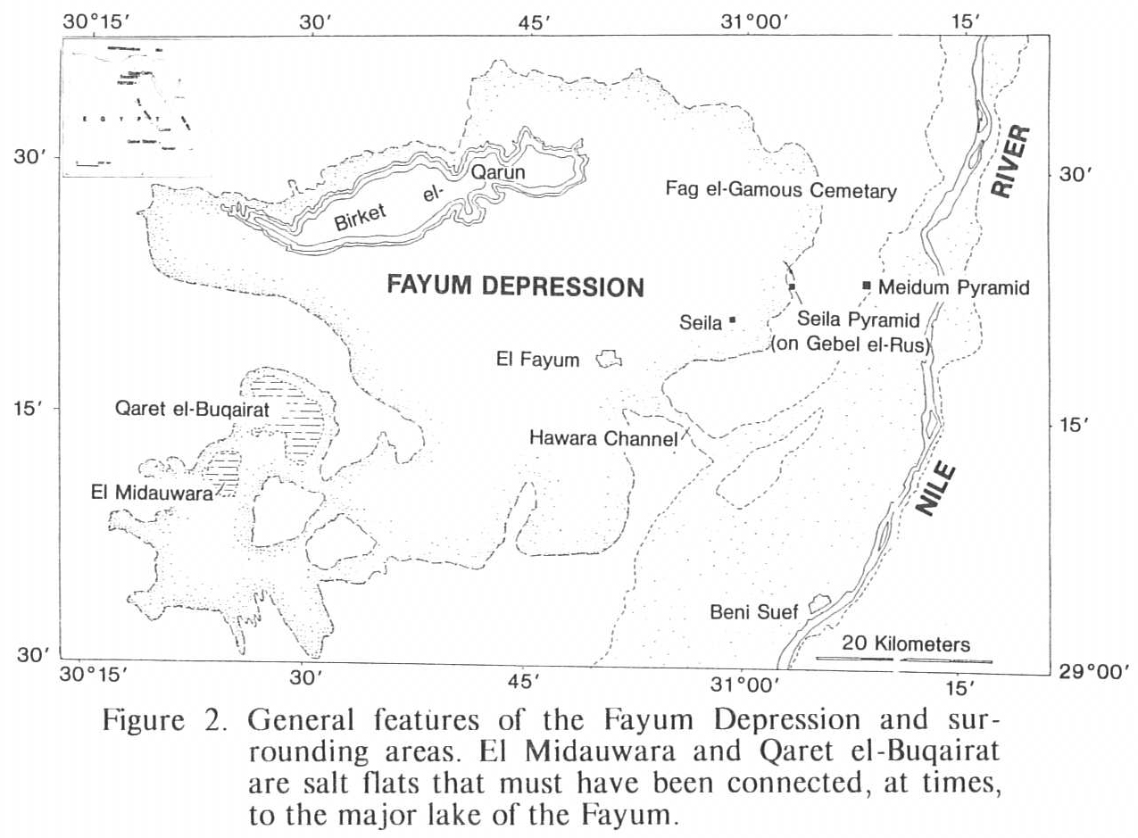
Early in the research project, Revell Phillips and Wilfred Griggs became concerned about relationships of bedrock geology and recent deposits to the archaeological sites in the Gebel el-Rus area (fig. 2). Later they additionally questioned uncertainties of origins of the Fayum depression, details of bedrock geology of the Fayum-Nile divide, the chemistry and hydrology of Birket Qarun, the lake that occupies the lowest area of the Fayum depression, and why the lake remains moderately fresh, even though it has been the site of deposition and evaporation for millennia. During the 1980 Field season, they also experimented with portable seismic geophysical equipment for location of tombs, etc.
Russell Hamblin undertook a detailed study of bedrock geology in the Gebel el-Rus area around the BYU archaeological site during the 1984 field season as part of the team. It was my good fortune to join the team for a short while and to participate in the multidisciplined investigation of the early cemetery. To Wilfred Griggs of Ancient Studies and Revell Phillips of the Department of Geology at Brigham Young University, I extend my appreciation. It was largely through discussions of their 1981 field activities that we saw the potential for more detailed investigations of the geology and natural history of the eastern Fayum and the area near the Seila Pyramid. It was investigation into materials and sources of material for construction of the Seila Pyramid and popular press notices on construction material of the pyramids at Giza that prompted us to consider further study of sources for materials for other monuments of Egypt.
Sources of Material for Monument Construction
In approximately 400 B.C., Herodotus visited what is now Libya and Egypt and observed the pyramids of limestone, probably in the Giza area. He noted that the limestone contains seashells and concluded that the sea, at one time, covered part of northern Africa because of similarities of the fossil shells to those of organisms then living along the shores of the Mediterranean Sea. He also noted the small fusiform fossils, now known as nummulites, that are common in some blocks, and thought that they were petrified millet that was fed to the workers. He surmised that some millet grains became mixed with the mud and then were turned to stone as the building of the pyramids proceeded. For many years, geologists with greater understanding of limestones have described the pyramid blocks as naturally occurring limestones, probably acquired from the famous quarries nearby.
It appears that we have now gone full cycle. According to the Sunday Times (London) of 2 September 1984, Professor Joseph Davidovits, a chemist at Barry University, Florida, has concluded that the slaves in Egypt did not need to haul huge blocks of limestone from the quarries but that the blocks may have been molded at the site of construction of the pyramids at Giza out of cement.
The Times noted that from chemical analysis of the pyramid blocks, Davidovits found that limestones from the Turah and Mokattam quarries near Cairo are made of tight calcite crystals, whereas construction stones of the pyramids are considerably less dense and contain many bubbles. He also noted that the limestones of the pyramids contain up to 13% impurities, within the calcium carbonate, such as sodium carbonate, phosphate and silt, which he suggested must have come from the Nile. He also claims to have found other foreign bodies in the stones: organic phosphates like bird droppings, organic fibers like hairs. He concluded that the major blocks comprising the pyramids at Giza probably had different sources from the quarries and that the stones on the outer surfaces of the pyramids were poured like cement to produce a man-made limestone.
The similarity of the blocks that now comprise the major pyramids of the Giza area (fig. 1) to the massive Eocene Mokattam limestones that underlie the pyramids have long since been considered as essentially proven. To those familiar with limestone textures, there is no question about their natural occurrence and origin. The only question is the source quarries. Indeed, there have been few conclusive studies on sources of material for most of the monuments in Egypt. To those, like myself, unfamiliar with details of Egyptian construction and materials, there is a general assumption that sources of construction materials for the major monuments in Egypt have been well-documented and are well-known. It is surprising, even astounding, to find that definitive studies have not been undertaken.
Detailed investigations by Russell Hamblin during the 1984 field season have convincingly demonstrated that the Seila Pyramid on the crest of Gebel el-Rus (fig. 2) was constructed of locally-derived sandstones and limestones. The materials were quarried from Eocene exposures west of the ridge crest. The limestones out of which the pyramids at Giza were constructed have little texture or fabric in common with limestones that were utilized for construction of the Seila Pyramid, although both are roughly the same age. Such differences should allow definition of likely or certain sources.
During the 1984 field season, we visited the Meidum Pyramid, which is approximately nine km east of the Seila Pyramid on the margin of the Nile valley. It would have been an easy, largely downhill, haul to have moved rocks from the Gebel el-Rus down to the Meidum area. However, none of the blocks of the Meidum Pyramid we examined, unfortunately in a somewhat cursory fashion, appear to be locally derived, unlike those of the Seila Pyramid. On the other hand, many look much like chalky limestones of the Eocene Thebes Formation from near Luxor (fig. 1), so well-exposed in major exposures in the vicinity of the Valley of the Kings. These limestones are generally open and porous, smooth and uniformly textured, not like limestones of the pyramids and those found in quarries around Cairo, and not like the limestones of the Seila structure. Similarly, some of the oldest pyramids of the Nile valley at Saqqara (fig. 1) may have been made of blocks that are not of local origin. South of the step pyramid at Saqqara, several moderately deep excavations cut through the bedded limestone and siltstone, suggesting that local building stones may have been available. These rocks appear, again in brief examination, to be different from those used in major construction of temples of the area. These, too, may have been transported downstream, like the granite for statuary at Memphis or the finished granite blocks on the pyramids or Nubia Sandstone in other structures.
Granite and related intrusive igneous rocks used in the Nile valley have been termed the Aswan Granite, but even here, thinking of a single source for the stone near Aswan (fig. 1) may be somewhat questionable. We need to do a fuller investigation of sources of major construction stones for each of the monuments than has been done in the past. Structures built on both sides of the Nile near Luxor and the major monuments at Karnak include a variety of building stones. Some blocks may have been locally derived from the massive chalky limestone exposed in cliffs above the temples, or they may have been excavated at quarries from the same layers up river. Exposures of similar beds nearby may have been sources for the fine-textured, uniform limestones that were utilized for much of the construction in the middle and lower parts of the Nile valley. For example, limestone for the Meidum Pyramid may have come from quarries up river near Luxor. Currently, we do not know where they come from, and only more research will tell whether these first impressions are even tenable.
On first visits one is so overwhelmed by the awesome architecture of structures at Karnak and the magnificent bas-reliefs that one pays little attention to the basic stones of which the monuments are made. Such was our experience and we need to return to Karnak and each of the major monuments to ask specific questions of origins of materials. We also need to conduct an organized program of evaluation of source materials for individual monuments. It is uncertain, for instance, how much of the material was brought from the Gebel Silsilah area, 65 km north of Aswan (fig. 1), from the granite quarries near Aswan, from possible quarries near Luxor and Cairo, and whether many or few structures were made of locally derived rocks or of transported material quarried from exposures along the margin of the Nile River valley, or elsewhere in Egypt. The various building stones must have distinctive mineralogic and textural “fingerprints” that should allow us to trace their sources and to trace utilization, once their quarries have been identified.
Origin of the Fayum Depression
Various workers (Beadnell, 1905; Sandford and Arkell, 1929; Caton-Thompson and Gardner, 1926, 1929, 1934; Murray, 1951; Pfannenstiel, 1953; Said, 1960, 1962) have speculated both on the origin or origins of the Fayum depression, which now extends to 45 m below sea level, and on the origins of similar depressions across northern Egypt. Origins are still uncertain, however. Most of these topographic low areas appear to lack major bounding faults or folds that would allow easy explanation of the depressions. Some may be depressions cut by streams as sea level was lowered during the Miocene, concurrent with the Messinian dessication of the Mediterranean Sea. For example, the lowering of sea level would have allowed deep erosion of the Nile valley and its tributaries, which are now masked or filled and blocked by subsequent Pliocene deposits. The latter could have filled the channels and connected waterways as sea level rose in the Pliocene. At that time, the Nile valley was flooded, perhaps up to as much as 135 m above present sea level.
Most agents of erosion are limited by sea level, which is essentially the level below which erosion by running water, glaciers, etc., theoretically cannot proceed. Wind in arid environments, however, is one of the agents that may excavate below sea level, as long as the water table is not exposed. Perhaps the Fayum depression owes its origin to deflation in a dry environment when sea level was low.
I suspect that if the origin of the Fayum depression were specifically investigated, we might be able to contribute more than somewhat tangential studies by consistently asking the right questions. Most earlier workers were concerned with regional relationships and had little time to concentrate on possible origins and evidences.
The Fayum basin is rimmed by exposed bedrock, except in one or two possible openings to the Nile valley. To test whether these openings functioned as stream valleys, one would need to test the depth of Pliocene-Pleistocene fillings in them and the depth to Eocene bedrock in the “sill” areas. For example, what is the “sill” depth in the Hawara channel (fig. 2) or in the area of major Pleistocene cover at the southeastern margin of the depression? The Hawara channel and “sill” have reportedly been drilled and the sill is apparently higher than the base of the Fayum basin. However, breccia-based Pliocene deposits may have filled the channel, for it would be possible to confuse isolated Eocene blocks with bedrock. Perhaps geophysical investigations, utilizing the small portable seismic instrument like that used to locate tombs in earlier seasons, might allow confirmation of the sills around the basin. That would eliminate erosion by streams as a possible method of depression development.
Salinity of Birket Qarun
Birket Qarun is a lake 45 m below sea level (fig. 2) and is a remnant of Lake Moeris and probably earlier lakes that occupied the Fayum basin. The depression is a closed basin and appears to have been an area of evaporation. Yet the present lake is not hypersaline but has only approximately half the salinity of the Mediterranean Sea. Such low salinity is unusual, particularly when one considers that gypsum and other saline deposits are common in at least superficial sediments around the lake.
To understand the chemistry of the lake, we need to know how much Nile water has flowed into the depression. We need to investigate the pre-Nile water history of the lake basin and study the sediments for some depth beneath the lake, as well as analyze the chemistry and modern hydrology of the lake. One wonders if some of the saline salts brought into the basin are trapped there. Are there major salt deposits below the clay bottom of the present lake? Are the saline sabkhas of El Midauwara and Qaret el-Buqairat a record of salt withdrawal that helped Lake Moeris remain fresh, like the Gulf of Karabugas helps the Caspian Sea to remain relatively fresh? Is the lake stratified? Is some salt removed from the lake basin by wind action? Are some of the salts along the margin drawn up into plants by wicking, and similarly into porous sediments around the plants by capillary action, only to be blown out of the basin to help maintain moderately low salinity? How could we test the potential of wicking and removal of salt by the wind? Extensive gypsum has cemented aprons of debris in uplands around the Fayum depression. Perhaps these deposits are evidences of salt being removed from Birket Qarun and the Fayum. Is there an asymmetry in development of calcrete around the basin related to prevailing wind or major storm directions? Are the winds really salty and does the wind and wicking produce debris that can be transported out of the basin? We don’t know.
Lake Moeris and Birket Qarun Histories
Some early workers (Beadnell, 1905; Caton-Thompson and Gardner, 1929; Sandford and Arkell, 1929; Ball, 1939) wrote short statements about the general physiography of and made preliminary observations on the late Pleistocene-Paleolithic lake and on Egyptian-Roman Lake Moeris (fig. 2). The depression was reportedly converted into a major lake by Amenenhet I and his successors in the 12th dynasty. According to Said (1962, pp. 100–01), Lake Moeris was used as a regulator for flow of the Nile, with ponding during flood stages and release of water during low stages; but apparently under Ptolemites, Lake Moeris ceased to be utilized in this way and only the water required for irrigation was then allowed from the Nile valley into the depression. Said (1962, p. 101) reported that lacustrine deposits show that the approximate extent of a Paleolithic lake can be traced over a wide area of the depression, rising up to elevations of approximately 40 m above sea level.
Although the preliminary upper boundaries and crude histories may have been established for the lake, essentially, like the upper lake levels of Lake Bonneville were established by G. K. Gilbert, we know little of the vertical fluctuation of the lake, and studies like those done more recently on lake Bonneville need to be done on the Fayum lake or lakes. Investigation of cut terraces and the sediments that accumulated on the terraces and around the basin margin, combined with geomorphic analyses, could document the history of the 80 m of lake fluctuation. Analysis of the sedimentary record in the basin floor could document cycles of rise and fall of the lake. The stratigraphic record of high stands in the eastern part of the basin is preserved in only limited areas and there is some urgency to its investigation.
One wonders about plant succession near the fluctuating shoreline. Where the lake is partially filled in by sediments, the plants certainly will have left a record, if only one of pollen. I suspect that by analysis of cores through sediment fills of Birket Qarun, in the bottom of Lake Moeris, and around its margins, we could see a record of plant utilization throughout the occupation of the depression by man, as well as an earlier Pleistocene plant record. Analysis of cores through sediments may record cycles of Nile flooding and evaporation, as documented by the record of resistant pollen grains.
Analysis of diatoms, small siliceous microscopic plants, from the same cores could also help document changes of environments. I think the record in the bottom of the lake and around its margins will show diatom floral successions and variations as well as utilization of the lake by early Egyptian and Roman flooding and draining. The record might be expected to show the later influence of the Nile River or perhaps the earlier isolation of the basin from the river.
With analysis of the same cores and flanking sediments, we could show rates of addition of salt from the Nile. We should be able to measure introduction of carbonates and sulfates and, certainly, introduction of phosphates by man. With that we should be able to determine rates of sedimentation within the basin itself.
With modest investment in time and equipment, we could do shallow seismic studies across the lake basin using sparker profiling. Such techniques have proven to be effective in generating records in other shallow lakes. Such records may show spring areas within the basin, mark the lateral continuity of layers within the lake basin, and locate possible faults. Such data will tell us much about the history of the basin. We see great potential for interdisciplinary investigation of the Lake Moeris basin and occupation of its margin by paleolithic and later man. Lake cycles have considerable significance to the archaeology and the geologic history of the region.
Geology of the Basin Margin
With the detailed analysis of part of the basin margin by Russell Hamblin, in 1984, we have now looked in detail at far less than 1% of the bedrock of the periphery of the Fayum depression (fig. 2). Similar detailed analyses at selected areas around the basin could tell us much concerning the geology and history of the region. If judiciously located, such key detailed studies could provide correlation points for tying more generalized data into a meaningful network. We know little about the details of the geology of the lake basin. Such studies tied to archaeological studies and related natural and social science studies could produce an unparalleled multidisciplined analysis of a region.
Conclusions
As impressive as our written record will be and as impressive as our research can be in terms of impact on readers, the impact of involvement in a team project on researchers is considerably greater. A continuation and a broadening of the interdisciplinary approach to study of the Fayum area is necessary. For example, chemistry can contribute much about the people and their environment by analysis of trace elements in hair or bones. We need to involve palynologists, botanists, anthropologists, and archaeologists, workers with facility in languages, pathology, dentistry, history, clothing and textiles, zoology, statistics, all of whom could ask questions similar to those posed above and all of whom could help interpret the eastern Fayum.
References
Ball, J. (1939). Contributions to the geography of Egypt. Cairo, Egypt: Survey Dept.
Beadnell, H. J. L. (1905). The topography and geology of the Fay urn province of Egypt. Cairo, Egypt: Survey Dept.
Caton-Thompson, G., & Gardner, E W. (1926). Research in the Fayum. Anc. Egypt, Part I, 1–4.
Caton-Thompson, G, & Gardner, E W. (1929). Recent work on the problem of Lake Moeris. Geograph. J., 73, 20–60.
Caton-Thompson, G., & Gardner, E W. (1934). The desert Fayum. London: Royal Anthropological Institute.
Murray, G. W. (1951). The Egyptian climate: An historical outline. Geograph. J., 117 , 422–434.
Pfannenstiel, M. (1953). Das Qitartar der Levant II. Die Entstehung der agyptischen Oasendepressionen. Akad. Wissensch. u. Lit. Math. Nat. Kl., Mainz, 7, 337–411.
Said, R. (1960). New light on the origin of the Qattara depression. Bull. Soc. Geograph. Egypteset., 33, 37–44.
Said, R (1962). The geology of Egypt. Amsterdam-New York: Elsevier.
Sandford, K. S. & Arkell, W. J. (1929). Paleolithic man and the Nile-Fayum divide. Chicago Univ. Oriental Inst. Publ., 1, 1–77.
