The Geology of the Gebel El-Rus Area and Archaeology Sites in the Eastern Fayum, Egypt
Russell D. Hamblin
Russell D. Hamblin, “The Geology of the Gebel El-Rus Area and Archaeology Sites in the Eastern Fayum, Egypt,” in Excavations at Seila, Egypt, ed. C. Wilfred Griggs (Provo, Utah: Religious Studies Center, Brigham Young University, 1988), 45–73.
Russell D. Hamblin is a master’s graduate in geology from Brigham Young University.
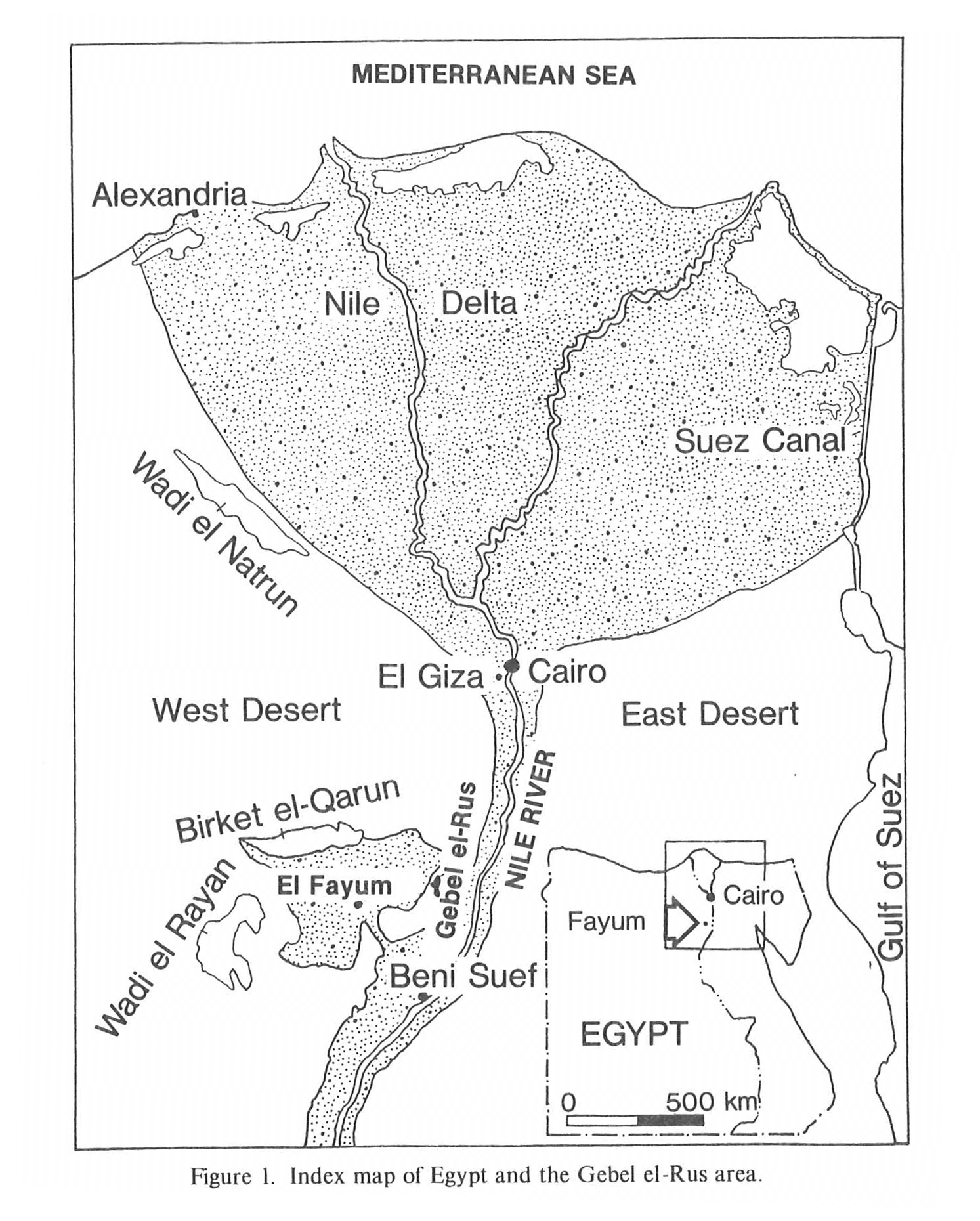
The Gebel el-Rus area is part of a 40 square mile archaeological site in the eastern Fayum in Egypt that Brigham Young University has received permission from the Egyptian government to study and excavate. Faculty members in the departments of Ancient Studies and Geology at Brigham Young University decided that analysis of the geology of the excavation sites and surrounding areas would be of geologic interest and would support the archaeological investigation. This paper will provide detailed stratigraphic and lithologic information on the area. Plans for additional archaeological and geological investigations on this historic area are also under consideration.
Some of the best exposures of Tertiary rocks in the West Desert of Egypt are found on Gebel el-Rus, along the divide between the Nile valley and the eastern Fayum. The western face of this divide is a relatively steep escarpment that rises from 20 m above sea level to the peak north of the Seila Pyramid at about 100 m. Barren Eocene and Pliocene strata are exposed on the ridge and over-look the lush cultivated fields of the Fayum depression.
Rocks are well hidden under a thick alluvial cover on subtle slopes on the eastern side of Gebel el-Rus and along the entire east face of the Nile-Fayum divide. The green Nile River valley and steep-walled Meidum Pyramid, 10 km east of Gebel el-Rus, are on lower slopes and valley fill.
Gebel el-Rus, a rather small mountain covering only about 8 sq. km, contains many interesting geologic features. An angular unconformity between Eocene and Pliocene beds, Pliocene paleochannels filled with debris-flow deposits, a variety of sedimentary structures, trace fossils, and distinctive faunas are some of the important aspects of the area that require local detailed studies.
There has been a lack of even moderately detailed geological studies in the eastern Fayum with respect to stratigraphy, paleoecology, and sedimentary petrology of the Eocene rocks.
Environments of deposition of rocks exposed in escarpments and hills around the Fayum depression and in surrounding regions have been discussed in a regional way by early workers, including studies by Beadnell (1905), Sanford and Arkell (1929), and Shata (1975). However, these and other studies have differed in interpretation of the stratigraphic section and its history. This study concerns a relatively small area with good exposures that was examined intensively in order to document evidences of environments and geologic history of these Tertiary rocks and to compare these data with those obtained by earlier regional studies.
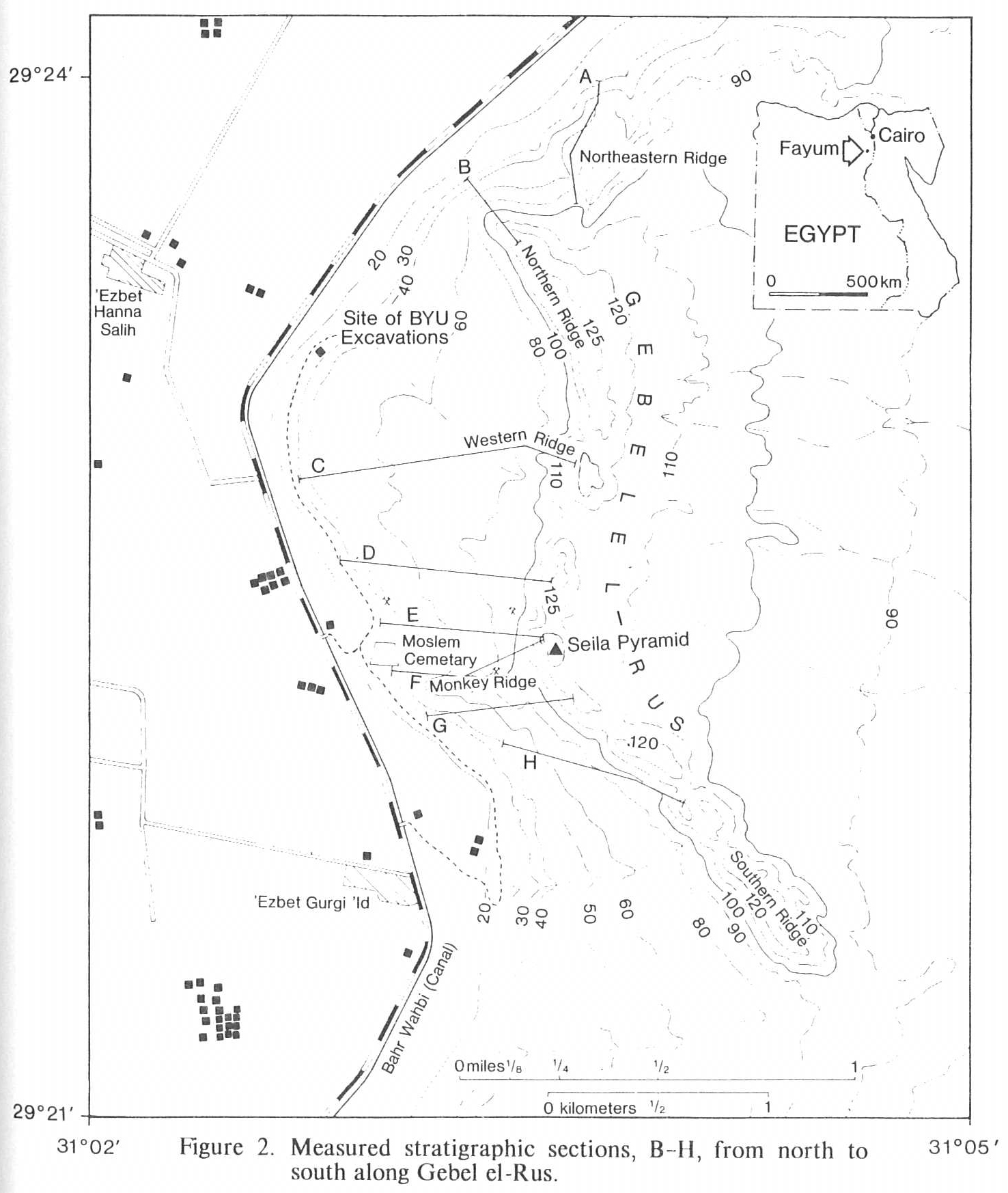
Geological methods applied in this study to document rocks, structures, and faunas include the following: measurement and description of eight stratigraphic sections, correlation of the various lithologic units and subunits between sections, construction of a geologic map on a scale of approximately 1:13,000, lithologic descriptions, and evaluation of paleontologic data. This study involves strata exposed on the western face and crest of Gebel el-Rus, which forms part of the escarpment ridge at the eastern edge of the Fayum depression. Gebel el-Rus is on the Nile valley-Fayum depression divide, approximately 8 km northwest of Seila, Egypt. The area is centered at approximately 29 degrees 24’ north latitude and 31 degrees 3’ east longitude (fig. 1 & 2).
The earliest geological studies of the Fayum were conducted in the 1890’s by M. Blackenhorn (1901, 1902), in which he discussed many of the geomorphological features of the depression and surrounding areas. Hugh J. L. Beadnell (1901, 1905) published some of the most extensive work ever done on the stratigraphy and lithology of Lower Eocene through Recent strata of the Fayum. Subsequent papers by Elinor W. Gardiner (1927, 1929, and 1934), K. S. Sanford (1929), 0. H. Little (1936), R. Said (1962), and Tamer (1975) are largely follow-up studies of Beadnell’s earlier observations. Most of these publications emphasize the regional geology of the Fayum depression, but many local areas were studied with little detail.
Studying in a foreign land can often be difficult and challenging because of differences in laws, language, and culture. Several Egyptians provided essential help to the archaeology project and to this geological study. I express my appreciation to the following: Dr. Ahmed Kadry, director of the Egyptian Antiquities Organization, Ali Khouly, director of Antiquities for Middle Egypt and former director of Antiquities for Middle and Lower Egypt, and members of the Permanent Committee of the Egyptian Antiquities Organization for granting Brigham Young University permission to excavate and work at the site of Seila. Appreciation is also expressed to the following for giving support and assistance to the research team during the 1984 season: Mr. Moustafa el-Zairy, chief inspector at Beni Suif, Mr. Ali Bazidi, chief inspector at Fayum, Mrs. Sami, inspector at Fayum, Mr. Akram Eshak, inspector at Fayum and inspector working with the excavation team on the site, and Mr. Sabri Gabbour, director of the museum at Kom Aushim. I also wish to thank Ramaddan Absed Mohammed and Abdel Setar Ahmed, who assisted and accompanied me in the field during my geological excursions at the site. Partial support for the study was provided by the Mormon Archaeology and Research Foundation, and Mr. Wallace Tanner, its president and founder.
Dr. J. Keith Rigby, chairman of the thesis advisory committee, and Drs. Jess R. Bushman and Wm. Revell Phillips, were members of the committee. Thanks is also given to Dr. C. Wilfred Griggs, director of Ancient Studies at Brigham Young University and the director of the project in Egypt. Dr. Phillips invited me to participate with the group. Phillips Petroleum Company and Marathon International Oil Company provided financial support for field work and thesis preparation. Staff personnel at Phillips Petroleum Company prepared many of the necessary thin sections of rocks and fossils from the study area. Micro-faunal identification and interpretations were provided by Dr. Stanley H. Frost.
Regional Structural Relationships
Said (1961), in describing the tectonic framework of Egypt, concluded that the country is composed of three structural units: the Arabo-Nubian massif, the stable shelf, and the unstable shelf. The Arabo-Nubian massif is the basement core, and these rocks are well exposed east of the Fayum in major ranges of the southern Sinai and along the Red Sea in the East Desert of Egypt.
The Arabo-Nubian massif is overlapped and surrounded by the stable shelf, an area of thin continental and epicontinental Cretaceous and Cenozoic units. The Upper Cretaceous-Lower Tertiary shallow-water Nubian Sandstone is overlaid by Eocene rocks, part of which were investigated in this study. The Eocene shale, limestone, and sandstone represent a major marine transgression that covered the stable shelf. The transgression of the sea began near the Late Cretaceous-Early Tertiary transition and ended with a regression that took place from the Middle Eocene to near the close of the Oligocene.
The stable shelf, according to Said (1961, p. 200) is characterized by the thinness of the sedimentary section, minor normal faulting, and the basin producing rift zones of the Red Sea-Suez region. Although major anticlinal features are lacking in the stable shelf, there are several domes that have broad and gentle flanks on all sides. Minor movement of these structures has produced local diastems rather than major unconformities.
Most of northern Egypt is considered part of the unstable shelf or mobile belt (Henson, 1961: 199). Compressional stresses responsible for SW-NE, NW-SE, and E-W trending folds and faults mainly began in Middle and Late Cretaceous time. Because of the incompetent nature of rocks of the unstable shelf, internal stresses were relieved through tensional movements and normal faulting resulted when compressive stresses were released.
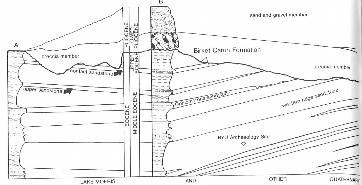
The Fayum area lies within Said’s stable shelf. Areas west of Gebel el-Rus and the Nile-Fayum divide, in the West Desert of Egypt, have been extensively faulted and folded. To the east, the Nile valley is also fault controlled. The Fayum depression and its surrounding escarpments, however, have escaped the effects of major faulting and folding. Gebel el-Rus area lacks any significant faults, but minor tilting of Eocene strata is apparent. A gentle northward dip of 3 degrees to 8 degrees of Middle and Upper Eocene rocks produced a subtle but observable angular unconformity between these rocks and overlying, essentially horizontal, Pliocene deposits.
According to Tamer (1975: 21), the Fayum depression overlies the axis of a major anticline and is affected by normal faulting. He described a great monoclinal edge that bounds the depression on the northern and eastern sides.
Eocene Deposits
Eocene strata exposed on the western flanks of Gebel el-Rus are represented by Middle Eocene Ravine beds and Upper Eocene Birket Qarun Formation. The Birket Qarun Formation was named from the large lake, Birket el-Qarun, which occupies the northern edge of the Fayum depression. The Ravine beds conformably overlie the Wadi el-Rayan Formation to the south and southwest of the Fayum depression. Middle Eocene Wadi el-Rayan rocks are composed of interbedded nummulitic limestones, reefal limestones, and shaly sandstones according to Beadnell (1905: 35–37). A marly limestone containing Nummulites gizehensis, a rather large foraminifera, marks the top of Wadi el-Rayan strata and base of the overlying Ravine beds. The Wadi el-Rayan Formation, although of different lithology, correlates, in time, with the lower Makattam Limestone exposed in major quarries near Cairo. Lithologic and paleontologic evidence suggests shallow water and warm climate during deposition of the Wadi el-Rayan and Ravine sediments.
The Birket Qarun Formation, which overlies the Ravine beds on Gebel el-Rus and northward, is overlain by the Qasr el-Sagha formation north of the Fayum depression. Qasr el-Sagha units are correlative to the upper Makattam or Maddi Formations near Cairo. Best exposures of these deposits are on steep escarpments immediately north of Birket el-Qarun. Qasr el-Sagha strata are characterized by argillaceous sandstones, mudstones, and limestones. Many important terrestrial vertebrates and Carolia placunoides, Ostrea fraai, and other marine fossils are present in these Bartonian age rocks.
The faunal association found in the Qasr el-Sagha Formation indicates accumulation in nearshore, shallow seas with adjacent fluvial systems. Such a relationship would be required for terrestrial vertebrates to be deposited together with marine mollusks.
The overlying estuarine Oligocene Qatrani Formation and nearshore deposits from the Qasr el-Sagha Formation are evidences of marine regression or shoreline progradation. According to Issawi (1972) several other sedimentary sequences deposited in northern Egypt indicate that the Tethys Sea regressed to the north during late Eocene and Oligocene times.
Stratigraphic Nomenclature
Beadnell’s stratigraphic nomenclature (1901 and 1905) included Lower Eocene beds in the Wadi el-Rayan series, Middle Eocene beds in the Ravine beds, and Upper Eocene in the Birket Qarun series and Qasr el-Sagha series. Said (1962: 101), however, used more formal stratigraphic nomenclature for the same units: Lower Eocene Wadi el- Rayan Formation, Middle Eocene Ravine beds, and Upper Eocene Birket Qarun Formation, and Qasr el-Sagha Formation. The present study emphasizes details of the Ravine beds and the overlying Birket Qarun Formation of the Eocene series.
According to Beadnell (1905: 42), some 60 m of strata forms the major section of the cliff that rises above the northern shore of the lake Birket el-Qarun. The basal 15 m of the Birket Qarun Formation is preserved on the northern flanks of Gebel el-Rus, in the research area. However, northwest of the Fayum depression, on Gebel Gehannam, the Birket Qarun Formation is over 50 m thick, and underlies the Qasr el-Sagha Formation. Middle Eocene strata exposed on Gebel Gehannam, referred to as the Gehannam Formation by Said (1962: 101), are correlative to the Ravine beds exposed on Gebel el-Rus.
Beadnell (1901: 37) named the exposed strata, bordering the arable fields of the Fayum oasis on the west, north, and east sides, the Ravine beds. This series is also exposed in el-Butts and el-Wadi ravines, both of which cut across the cultivated fields of the depression. Consistent ravine exposures of these Middle Eocene deposits explains the unit name.
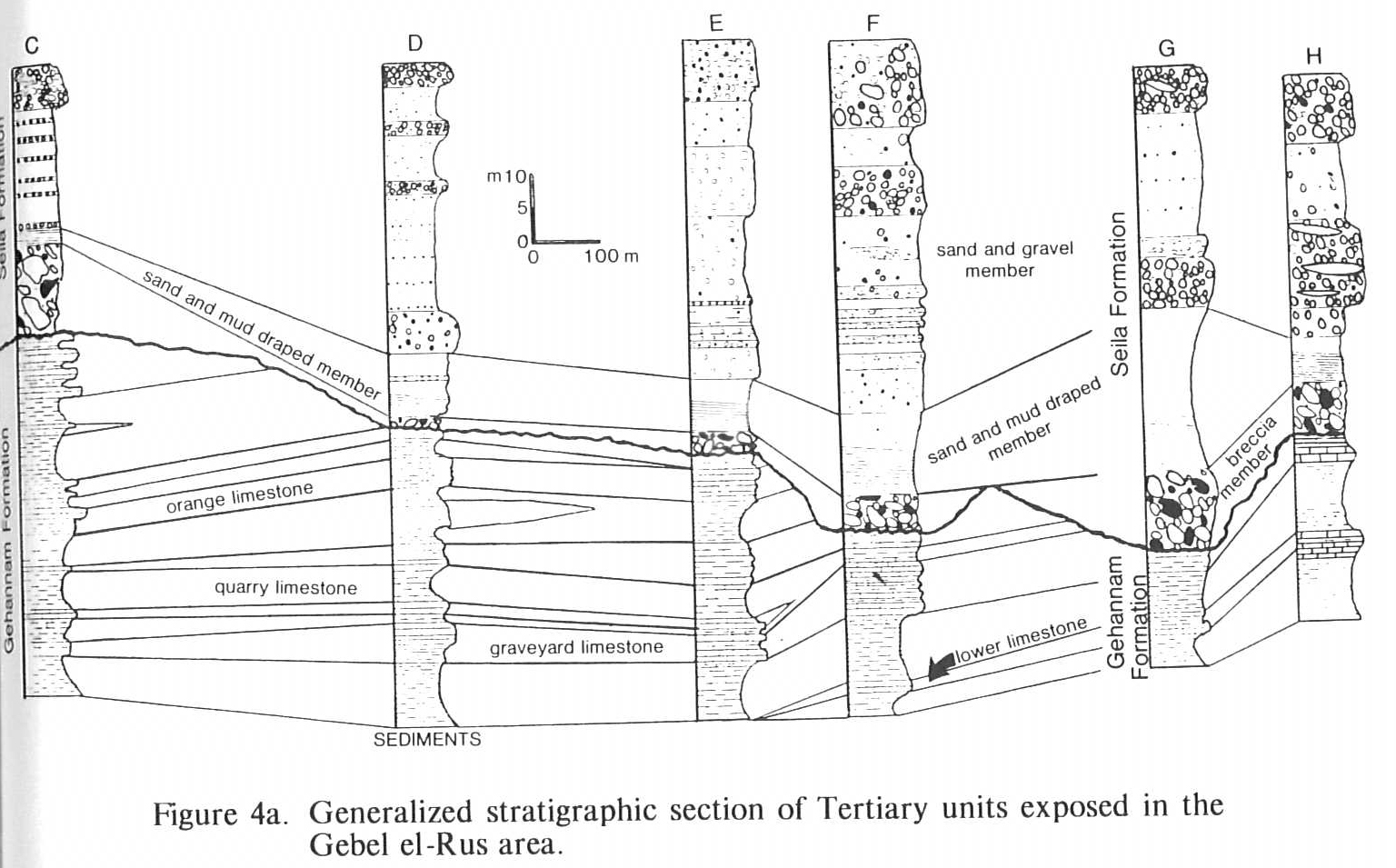
Several resistant Middle and Upper Eocene ledge-forming subunits are well exposed in the study area. Many of these are well-lithified calcareous sandstone and sandy limestone beds that are interbedded with shaly slope-forming marly beds. These key units are easily differentiated and correlated on the western flanks of Gebel el-Rus and have been given the following informal field names by the writer; from the bottom up, the “graveyard limestone,” “quarry limestone,” “orange limestone,” and “contact sandstone.” Each of these units is discussed in the description of Eocene deposits (fig. 3).
Lithologic Description
Eocene strata exposed in the Gebel el-Rus area are characterized by a variety of calcareous-clastic sediments that range from slightly calcareous mudstones to calcareous sandstones or sandy packstones. Rocks with small amounts of calcium carbonate composed 60 to 70 percent of the entire Eocene section and the remaining 30 to 40 percent are rocks with moderate to large amounts of calcium carbonate.
Topographic expression of Middle and Upper Eocene units is largely controlled by the amount of calcium carbonate present in the rocks. Lithologic units with little calcium carbonate cement form slopes and recesses; they remain poorly lithified and are easily eroded. Calcareous units, however, are well lithified and form minor cliffs where they are thick bedded, or resistant ledges where thin bedded. Gypsum, as lenses or veins, may also be responsible for steep cliff-like slopes. Gypsum commonly fills fractures as veins in massive rocks and as concave-up, lense-like structures in thin cross-bed sets. Gypsum is usually not very resistant to erosion, but, in the desert, it forms weakly resistant ledges and ridges.
The most abundant rock types of the Eocene section in the study area are mudstones and argillaceous siltstones. These fme-grained clastic deposits form wide, gentle slopes and broad, flat areas where the deposits are thick and they erode to recessive units or undercuts that separate more resistant beds. These deposits, poor in calcium carbonate, are generally brownish and olive gray under a veneer of loose debris or gypsum-cemented lag.
Eocene strata made up of units with moderate to large amounts of calcium carbonate are marls, silty marls, calcareous sandstones, and sandy limestones or packstones. These units form steep slopes, when moderate calcium carbonate is present, and ledges and minor cliffs, when the units are rich in calcium carbonate.
Limestones that lack abundant terrigenous material are generally thick bedded and massive. Where terrigenous clastic materials increase so do trace fossils and sedimentary structures, such as bidirectional short-wavelength ripple marks, cross-laminations that generally trend N125E, and load casts from 10 cm to 1 m in diameter. Calcareous sediments range from yellowish-orange to grayish-orange. Rocks that lack abundant clastic constituents, such as chalky and pure limestones, tend to be very pale orange to very light gray or nearly white.
Well lithified, thick-bedded limestones, packstones, and wackestones in the study area have been used as building stones for centuries, as evidenced by several building structures and many worked quarries. Building stones for the third Dynasty Seila Pyramid were apparently quarried from these sites. Recent tool markings and dynamite scars are evidences that these quarries have also been used for modern buildings.
Petrographic analysis shows that these rocks are texturally and mineralogically submature. Grain size ranges from coarse silt to fine and medium sand, and grain framework from sorted to fairly well sorted; the sand grains are mostly angular and subangular. Only a few grains have rounded edges or corners, but most approach equant shapes.
All terrigenous units are dominated by quartz although the framework of many contain an array of accessory minerals, e.g. plagioclase, microcline, hornblende, bio-tite, muscovite, zircon, polycrystalline quartz, and quartz with minor fluid inclusions. Angular calcite fragments and rounded glauconite grains are present in many samples. The presence of these accessory minerals indicates a granitic source. Clays rich in hematite and limonite form the matrix in most units and cements are usually microsparite and micrite.
Subdivision of Eocene Strata Based on Resistant Units
Middle and Upper Eocene deposits exposed on the western flanks of Gebel el-Rus were subdivided on the basis of alternating major resistant ledge-forming and slope-forming units. Thick resistant limestone units range from 1 to 3 m thick and are generally packstones and wackestones. Minor subunits form ledges 0.5 to 1.0 m thick and usually consist of sandy marl and silty limestone. Some key units may contain two to four ledges. Ledges are separated by thin, recessive beds, usually mudstones.
Informal subdivisions of the Middle Eocene exposed in the study area are, from bottom to top: “graveyard limestone”, “quarry limestone”, “orange limestone”, “western ridge sandstone”, “Ophiomorpha sandstone”, “last sandstone”, and “contact sandstone”. These resistant units are easily correlated between measured sections and are separated by units of mudstone or argillaceous siltstone that form broad slopes or covered intervals (fig. 2).
Facies Interpretations
Most of Egypt was covered by a warm, shallow sea during the Early and Middle Eocene that resulted from a major marine transgression of the Tethys Sea. Marine sediments were deposited on deformed Cretaceous rocks in northern Egypt. Thick Paleocene and Eocene sections accumulated in structural basins but Eocene deposits are thin and Paleocene deposits are missing over anticlinal highs. According to Salem (1976: 34), well data reveals such basins separated by elongated structural ridges.
Deposition of fluvial and interdeltaic facies north of the Fayum depression are the result of shoreward progradation coupled with a northward regression of the sea during the Late Eocene and Early Oligocene. The Fayum region was later an area of topographic prominence due to crustal upwarping during the Oligocene and Miocene. Thus, the study area was subaerially exposed beginning in the Oligocene and remained so until it was invaded by an arm of the Mediterranean Sea during the Pliocene.
Deposits of the Middle Eocene Ravine beds and Upper Eocene Birket Qarun Formation exposed in the study area accumulated in transgressive and regressive shallow seas. Sandy carbonate units interbedded with mudstones represent oscillations between high and low energy states. Ledge-forming calcareous sandstone beds, such as the “Ophiomorpha” and “contact” sandstones were deposited in higher flow regimes than the silty mudstones that occur below and above each unit. Finer sediments were winnowed away in the strong currents that deposited the sands. Firm substratum, of thick sand accumulation, provided suitable environments for such organisms as clams and oysters.
Faunal assemblages from Ravine bed and Birket Qarun strata in the study area are good indicators of subtropical, shallow seas at the Late Eocene-Middle Eocene interphase. Nummulitid foraminifera, sessile benthonic organisms in sublittoral neritic zones, are often abundant in many exposed sandy carbonate beds. Modern large foraminifera similar to ancient nummulites live in shallow seas of the tropics.
The “orange limestone” contains frequent clusters of nummulites that were either used by other organisms to fill or to line shallow burrows, or they crawled into the burrows themselves to escape dessication in very shallow water. This and many other units contain scattered microscopic echinoid spines and plates, oyster and clam shell fragments, and bioturbated beds. Although some sedimentary structures are present in many sandy carbonate beds on Gebel el-Rus, most bedding is massive, the stuctures having been largely destroyed by bioturbation, possibly by the burrowing of sediment-feeding clams. These findings indicate that abundant life processes and moderate to strong currents were factors of the environment during deposition.
Many of the preserved sedimentary structures give evidence of nearshore shallow seas. Short wavelength, cross-lamination structures are present in a few of the ledge-forming units. The “ Ophiomorpha sandstone” contains the best example of cross-bedding. Well preserved ripple-drift, cross-laminated sets in this unit indicate rapid subaqueous deposition by currents with moderate flow regimes. The bidirectional pattern of the cross-laminations in many sandstone units is evidence that tidal currents were important factors of the environment during sedimentation. Hummocky cross-bedding in the “contact sandstone” presents the possibility that many of these calcareous sands were deposited during storms or other violent events.
Undulating contacts between shaly units and overlying sandstones and loadcast structures into mudstones are abundant in the higher subunits of the study area. The “western ridge sandstone” and “Ophiomorpha sandstone” contain such structures, although the best examples are the “contact sandstone” where large, bulbous loadcast structures, nearly a meter in diameter, protrude down into the underlying mudstone bed. Contact irregularities and loadcasts result either from calcareous sands rapidly deposited on the muddy floor of a regressive sea or from storm-driven sand deposited over mud in a transgressive sea.
Moderate amounts of plagioclase, microcline, hornblende, and other chemically unstable minerals indicate that the sandy carbonate sediments are mineralogically submature. Although grains are generally sorted, they range from angular to subrounded and these sediments are also considered texturally submature. The presence of feldspars, micas, hornblende, and other unstable accessory minerals in these Eocene rocks indicate a granitic source terrain not far from the site of deposition and minimal reworking of the sands after deposition.
Pliocene Deposits
Most high level ledges and cliffs on Gebel el-Rus are horizontal Pliocene deposits. Ridge-forming breccia deposits, composed of large subangular blocks detached from numerous Eocene units, are the earliest Pliocene deposits in the section. Laminated sands and sandstones which drape over these beds form steep slopes and are overlain, in turn, by ledge- and cliff-forming gravelly sandstones and sandy conglomerates.
Aigner (1983) described Pliocene deposits near Cairo, on the Giza Pyramids Plateau, which are similar to the breccia deposits on Gebel el-Rus. According to Aigner (1983: 319), large blocks from Eocene bedrock were detached by erosive wave action accompanying a transgressing Pliocene gulf.
According to Said (1981), the Pliocene gulf flooded the Nile River valley from the Delta to Aswan. In this estuary, 12 km wide and over 1300 km long, over 460 m of sandstone and sandy mudstone and over 1500 m of shale were deposited at the Abu Madi Formation and Kafr el-Sheikh Formation respectively. Several other Pliocene gulf deposits are discussed by Said (1981: 100–101).
Stratigraphic Nomenclature
The Pliocene deposits of Gebel el-Rus are here subdivided into three distinct beds—coarse breccia blocks, laminated sandstone drape, and sandy, gravelly conglomerates, or lower member, middle member, and upper member.
No formal lithostratigraphic names have been applied to Pliocene deposits of the Fayum region. Lithologies and deposition environments were used by early workers to describe the Pliocene rocks. For example, Beadnell (1905: 37) noted strata exposed high on Gebel el-Rus and called them Pliocene gravel terraces; Said (1962: 105) called the same deposits Pliocene estuarine and fluvitile gravels; and Little (1963: 228) described the coarse breccia deposits in the Fayum region and called them Pliocene slipped masses.
Pliocene deposits in the Gebel el-Rus were, in this study, subdivided lithologically for an informal nomenclature. The oldest and lower member of the Pliocene is here termed “breccia beds.” This unit, at the Eocene-Pliocene contact, is composed of large reworked subanguiar blocks of Eocene units. Two types of breccia have been recognized in this study: channeled debris flow deposits and nonchanneled, or sheetlike, debris flow deposits.
The middle Pliocene member is a unit here termed “Pliocene sand drape.” These laminated sands and sandstones overlie the “breccia beds” with a sedimentary dip. The “Pliocene sand drape” member is named from the unusual manner in which the clean, poorly lithified sands and sandstones drape over the irregular debris flow deposits.
The upper member of the Pliocene is here termed the “sandy, gravel conglomerate” member. Poorly sorted and lithified sandy gravels, gravelly sandstones, and gravelly conglomerates form the prominent ledges, cliffs and peaks on Gebel el-Rus.
Lithologic Description
Relatively dark Pliocene deposits overlie and cut into light-toned Eocene rocks with angular discordance. Pliocene deposits range from the lower coarse subangular debris flows to middle laminated interbedded sand, unlithified clay; and sandstones to gravelly sandstones and sandy, gravelly conglomerates of the upper units. These Neogene rocks form prominent cliffs and ledges on the western face of the north-south ridge of Gebel el-Rus but blanket the gentle eastern slope that sweeps down to the Nile valley. The highest altitude of Pliocene sediment in the study area is the cap on “northern ridge” and its lowest outcrop is only 30 m above sea level on the east-west “monkey ridge.”
The oldest Pliocene deposits on Gebel el-Rus, here termed the “breccia bed” member, are composed of subangular blocks of Middle and Upper Eocene calcareous sandstone. These blocks range from 0.5 to 3.0 m in diameter and occur in lenses and irregular sheets that overlie and partially truncate Middle and Upper Eocene strata. Many of these grayish-orange, Eocene-derived blocks are fossiliferous, containing shelled invertebrate faunas such as Middle and Upper Eocene nummulites, turritellid gastropods, and bivalves (clams and oysters). Some blocks are essentially oyster coquinas and other less fossiliferous blocks contain a few Ophiomorpha and Thalassinoides trace fossils and faintly preserved, small-scale ripple marks and cross-laminations. Some of the nonfossiliferous sandy limestone blocks are concretionary. Blocks of the “breccia beds” member are densely packed and surrounded either by a poorly lithified sandy-silty matrix or a partially lithified, argillaceous matrix.
“Breccia beds” that are lenticular are here termed “channeled debris flow deposits” and form prominent ridges on Gebel el-Rus (i.e. “northern ridge,” “western ridge,” and “monkey ridge”). These deposits range from 10 to 30 m deep, from a few meters to over 120 m wide, and from 10 m to nearly 1 km long.
Sheet-like breccia deposits are continuous with the debris-filled lenses and conjoin the ridges as nonchanneled debris flows. These sheet-like accumulations have a poorly lithified matrix of fine-grained sand and silt without significant mud or clay. Channel fill and sheet-like breccia deposits are apparently contemporaneous.
Breccia deposits in the study area, excluding those on “northern ridge,” are overlain by poorly lithified sandstones that appear to grade continuously upward from the sandy matrix of the sheet-like breccia. Sandstones of this middle member, here termed “Pliocene sand drape,” are unfossiliferous, pale yellowish-orange and grayish-orange, fine-grained, and are fairly well sorted. Grains are angular to subrounded. They drape over the “breccia beds” with dips ranging from 20 degrees southeast at the base, to essentially horizontal near the top of the beds. Well-lithified sandstone ledges, 1 to 8 cm thick, are cemented by calcium carbonate and may contain worm tube-like trace fossils, parting lineations, and small groove casts.
Pliocene sands are derived from local sandy Eocene carbonates. Petrographic studies of Pliocene sand show mineralogical and textural similarities to many Middle and Upper Eocene units. Southeastward depositional dips, cross-bedding that trends N135E, angular grains, and the presence of relatively unstable minerals, such as feldspars, micas, and hornblende, indicate a local source to the west or northwest.
Grayish-brown mudstone locally overlies the “breccia beds,” especially between sections C and F. It is rich in bentonitic clays, never exceeds three meters, and usually lenses out north and south where it is exposed on the western flank of Gebel el-Rus.
Poorly lithified gravelly sandstones and sandy-pebbly conglomerates overlie the middle member sand and mud-stone deposits. These form the upper member, here termed “Pliocene sandy and gravelly conglomerates” and contain numerous sandy, pebbly, and gravelly lenticular masses. Imbricated clasts (trending N135E), planar cross-bedding in sandy-pebbly lenses (trending N135E) and trough cross-bedding in sandy lenses (trending N125E) are characteristic of the ledge-forming conglomerates. No indigenous plant or animal fossils were found in Pliocene deposits on Gebel el-Rus; however, reworked Upper Eocene clams, oysters, and snails occur as second-cycle shells and shell fragments. Many clasts of Eocene sandstone and limestone contain Middle and Upper Eocene gastropods, clams and oysters.
Fragments of silicified wood, up to 1/
Fades Interpretation
Breccia lenses are the earliest Pliocene deposits in the area of study. They are interpreted as debris flows that have cut channels into upper Eocene strata, on “northern ridge,” and into Middle Eocene strata on “western ridge” and “monkey ridge.” They represent several events of subaerial mass wasting. Angularity, large size and distribution of clasts indicate the source to be Eocene cliffs and steep slopes to the west where the present-day Fayum depression lies.
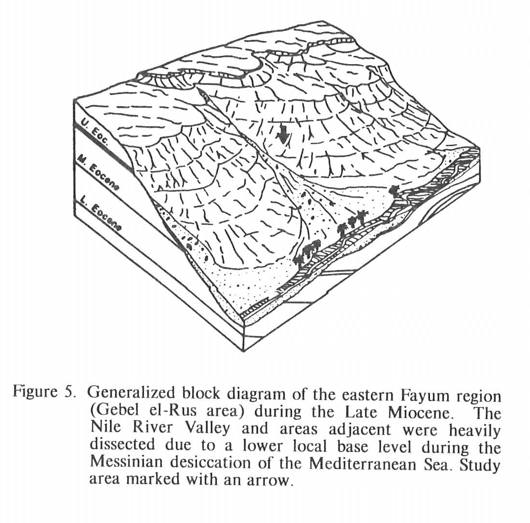
Areas along both the west and east banks of the Nile valley had been dissected by streams before the beginning of the Pliocene. Messinian lowering of the Mediterranean Sea initiated entrenchment of the Nile which resulted in a deep Nile valley gorge. Deep erosion also dissected the northern Egyptian Eocene platform, including the Fayum region.
Breccias, like the “breccia beds” in the study area, are common in many locations along the Nile River valley. According to Sanford and Arkell (1933: 1092), many coarse breccias occur to the south in the Thebaids on the Nile’s west bank above Armant. Little (1935: 228) mapped many of these deposits along an ancient northern shoreline of the Pliocene Gulf. The present study confirms Little’s observation that blocks often dip 5 degrees to 15 degrees toward the west and northwest. However, some blocks of the channeled debris flow deposits dip west 30 degrees to 50 degrees and the average orientation is best described as ran -dom.
According to Said (1981: 20), the position of the Nile River valley is controlled by tectonics and Gorshkov (1963: 101–105), notes that the valley has been the site of numerous major historic earthquakes. Said (1981: 21) suggested that movements of the “slipped masses,” which accumulated at the foot of cliffs in the proto-Nile valley, were induced by earthquakes. However, modern slumps of Middle and Upper Eocene units on the flanks of the “northern and northeastern ridges” of Gebel el-Rus, have apparently been detached and accumulated by normal subaerial erosion processes. The writer proposes that ancient slumps may also have formed by the winnowing of erodible units below the slumped masses.
Little (1936, p. 228) described the source horizons for the ancient slumps and noted that they have since been eroded northward from 10 to 20 km. These source rocks formed Pliocene strike ridges subparallel to the modern Nile valley. Catastrophic debris flows, which likely resulted from flash floods, had potential to transport large blocks and erode deep channels.
“Breccia beds” of the study area most likely resulted from subaerial mass wasting and mud and debris flows beginning in early Pliocene. Aigner (1983: 118) suggested, however, that similar beds near Cairo resulted from wave erosion that accompanied the transgressing Pliocene gulf. He further proposed that detached blocks were deposited directly into the estuary. Little (1936: 228) hypothesized that many slumped block deposits scattered along the Nile River valley mark the ancient shoreline of the Pliocene gulf.
Channeled debris flow deposits at Gebel el-Rus are terrestrial, not subaqueous. Many of the paleochannels slope from west to east, following the paleoslope into the gulf rather than paralleling its shoreline. The sheet-like slumped masses were probably detached like the modern debris accumulations on Gebel el-Rus and subsequently washed into channels.
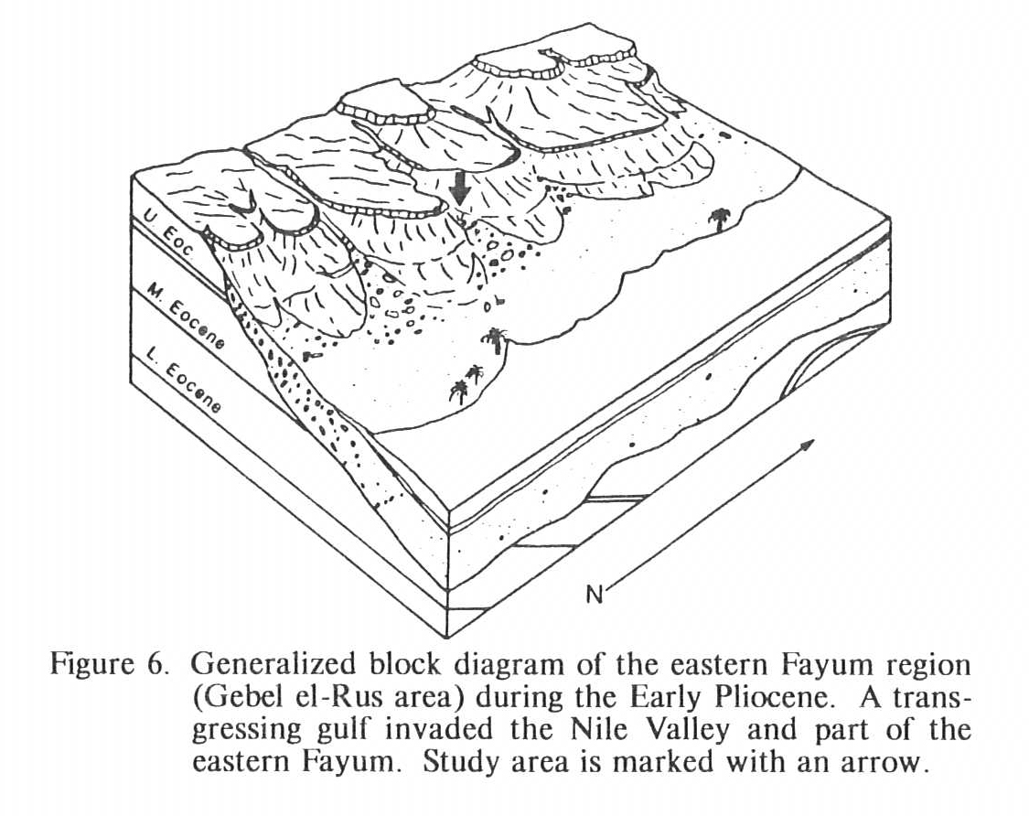
The Pliocene sand and mud that overlies the “breccia beds” represent a fining-upward sequence deposited along the margins of the transgressing Pliocene gulf. Attitudes of the sandstone beds are due to the southeastward paleoslope and differential compaction of the water-saturated sediments over the irregular upper surface of the “breccia beds.” These sands are too well sorted to be alluvial and grains are too angular and the deposits too muddy to be eolian. Occasional clayey mudstone lenses in the sand support the theory of marginal marine or estuarine deposits, and that they accumulated where the Pliocene gulf transgressed over at least some of the eastern Fayum.
Just as a fining-upward sequence indicates transgression of the Pliocene gulf, a subsequent coarsening-upward sequence marks its regression. The moderate dipping sand deposits grade upward into a horizontal sandstone which suggests flattening the paleoslope. Late Pliocene deposits are mostly pebbly and gravelly sandstones, sandy pebble conglomerates, and, at the top, coarse pebble to cobble conglomerates, as the gulf withdrew from the eastern Fayum.
Cliffs and steep slopes retreated northward in later Pliocene as the result of headward erosion of fluvial systems which emptied into the retreating gulf from the west and northwest. Sediments deposited in this environment are preserved near the summits and high ridges of Gebel el-Rus. These partially lithified sandstones, containing numerous pebble and gravel lenses and reworked Eocene gastropods and oyster and clam shells, are characteristic of a braided stream-alluvial fan complex. The source of these sands and gravels was Eocene sandstones in surrounding Pliocene cliffs. The later appearance of chert-dominated gravel lenses suggest fluvial systems energetic enough to transport coarse sediments from Oligocene rocks now preserved 30 km to the northwest.
Chert and quartzite clasts are likely from Oligocene interdeltaic and fluvial gravels. Said (1962: 103–104) described fluvial, estuarine, and marine gravels north of the Fayum. These sediments were transported and deposited by a proto-Nile River. The local source for cherty gravels on Gebel el-Rus is not known at the present. Quartzite clasts suggest a metamorphic source.
Gravelly conglomerates intercalated with the sandstone lenses, which outcrop near the peaks of Gebel el-Rus, probably accumulated in braided streams. Multiple scour-and-fill structures, poor sorting, planar cross-bedding, multiple-bidirectional low cross-bed sets, and imbricated clasts support this proposal. Paleocurrents ranged from N100E to N145E.
Pliocene-Eocene Contact in Unconformable Relationship
The angular Eocene-Pliocene contact is well exposed on the west and north flanks of Gebel el-Rus. The unconformity is accentuated by a distinct undulating erosional surface, especially evident along “northern ridge,” and light Eocene rocks abutt darker Pliocene rocks in exposures between “western ridge” and “monkey ridge.”
The unconformable relationship in the study area ranges from a disconformity to a minor angular unconformity. Angular discordance is most apparent north of “monkey ridge” on the west flank of “northern ridge.” On the south side of “northern ridge” Eocene strata dip 5 degrees northwestward beneath horizontal ledge-forming Pliocene units. The angular relationship becomes readily apparent as the Eocene “Ophiomorpha sandstone” and “contact sandstone” are traced southeastward along “northern ridge.” These units dip into the subsurface north of the study area but are truncated southeastward by Pliocene “breccia beds” between “northern ridge” and “western ridge.” Angular discordance truncates the “western ridge sandstone,” “graveyard limestone,” and “orange limestone” northwest of Seila Pyramid.
Near “western ridge,” the “western ridge sandstone” is essentially horizontal; the unconformity becomes more angular southward between “western ridge” and “monkey ridge” and decreases again to a disconformity south of “monkey ridge.”
A Geologic History in Summary
Most of Egypt was covered by the Tethys Sea during the Early Tertiary Cenomanian transgression. Paleocene and Lower Eocene sediments were deposited on an undulating surface of folded Cretaceous strata, thick deposits in structural basins and thin Lower Eocene sediments over anticlinal highs.
Minor gentle transgressive and regressive events in the Middle Eocene are recorded by gradual shifts of broad facies patterns in northern Egypt. Eocene strata in the study area correlate well with Eocene rocks throughout northern and central Egypt as part of a sheet of sediments uniformly deposited over that large region. Middle Eocene sediments of the Fayum and surrounding regions accumulated in open, shallow subtropical seas where tides influenced sedimentation (fig. 4a).
Seas regressed from northern Egypt during the Late Eocene and throughout the Oligocene. Upper Eocene littoral and tidal environments graded into Oligocene estuarine and fluvial conditions north of the Fayum depression. Progradation of terrestrial deposits accompanied withdrawal of the seas. Much of the Upper Eocene and all Oligocene and Miocene deposits are absent in the eastern Fayum, suggesting Mio-Pliocene erosion, and the region may have been subject to subaerial erosion from the beginning of the Oligocene.
Contemporaneous with the Late Eocene-Early Oligocene regression was gentle regional folding and faulting of older strata in northern Egypt. This diastrophic event was responsible for uplift of the Eocene platform. Basalt flows, which originally covered a large area between Cairo and the Fayum, were extruded during the Late Oligocene and Early Miocene. These volcanic events were apparently concurrent with uplift of pre-Miocene rocks north of the study area (fig. 4b).
Eocene strata of Gebel el-Rus were deposited on the stable part of the North African shelf but near the unstable part. Therefore, rocks in the Fayum area show only limited folding and only minor faults. Upper and Middle Eocene rocks in Gebel el-Rus generally dip north at 5 degrees to 10 degrees in a regional trend only locally interrupted by low anticlines and synclines.
The Eocene platform was extensively dissected during the Late Miocene. Erosion was strongly accelerated by steepened gradients produced by lowering the local base level thousands of feet when the Mediterranean Sea dried up during the Messinian. The Proto-Nile River reacted by eroding a deep, narrow gorge over 1300 km long. Pre-Pliocene rocks adjacent to this canyon and on the northern Egyptian platform were also deeply dissected (fig. 5).
The early Pliocene record begins in the Fayum area with debris flows, often confined to earlier channels. Where preserved, these beds delineate surface relief at the beginning of the Pliocene and also the paleoshoreline of a marine transgression. This Pliocene gulf is documented by a fining-upward sequence of sand and clayey muds deposited over the coarse debris flow deposits. The intensity and direction of the paleoslope is suggested by layering in the sands which dips from 5 degrees to 20 degrees toward the southeast. A coarsening-upward sequence of gravelly conglomerates was deposited over the sands and muds and represents coarse marginal debris as the Pliocene Gulf regressed from the study area. These later Pliocene braided stream-alluvial fan deposits transported and reworked older deltaic gravels from the northwest (fig. 6).
Steep slopes and cliffs at least as young as late Pliocene stood where the eastern side of the Fayum depression now lies, and since that time have been eroded back 25 or 40 km to the north. Paleochannels filled with debris flow deposits and braided stream paleochannels both show sediment transport from northwest to southeast out of a high source area now occupied by the Fayum depression.
Absence of Pliocene rocks in the Fayum oasis and the presence of Pliocene deposits rimming Nile-Fayum escarpments and derived from local western sources demonstrate that the Fayum depression, as we know it, did not exist during the Pliocene. The Pliocene gulf that occupied the Nile valley would likely have filled a nearby topographic low like the Fayum depression and at least some sedimentary record of it would have been preserved. The level of the gulf was at least 80 m above the present Nile river, as interpreted from the Pliocene clay deposits on Gebel el-Rus. Paleocurrents, documented by many sedimentary structures in the Pliocene deposits give strong evidence that sediments were transported from western and northwestern sources. The large size and angularity of blocks, derived from Eocene units and deposited in paleochannels, support the proposal that their source was nearby highlands that existed in the area where the depression presently lies. Pliocene rocks on Gebel el-Rus are from sources that no longer exist and were deposited on areas of low relief on slopes facing the Nile valley.
Excavation of at least the eastern part of the Fayum depression must have taken place subsequent to deposition of all Pliocene rocks on Gebel el-Rus, probably beginning in late Pliocene or early Pleistocene. The origin of the depression is unknown, however, it may be the result of a number of complex mechanisms, including regional subsidence due to minor faulting, erosion of minor structural features, intense mechanical erosion of thick unlithified mudstone units not overlain by resistant Pliocene “breccia bed” deposits and chemical erosion of limestone units when humid climatic conditions prevailed, and later subaerial wind erosion for final modification during arid Holocene times. Periods of glaciation during the Pleistocene, lowered global sea level hundreds of feet and additional removal of Eocene rocks from the Fayum depression probably resulted from erosive processes attendant to lower base level and wetter climate.
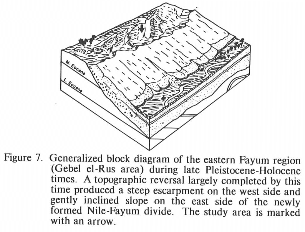
The Pleistocene was a significant epoch for the geomorphology of the Fayum region because, during this time, a major topographic reversal occurred. Gebel el-Rus and other highland areas along the eastern Fayum margin were low relief during the Pliocene. Valleys that sloped toward the deep proto-Nile gorge were Filled with resistant debris flow and gravel deposits that became areas of high relief. Source areas that once stood as a high platform with prominent eastward-facing cliffs were lowered by erosion to negative relief during the Pleistocene (fig. 7).
Natural excavation of the Fayum depression was essentially completed by the Paleolithic and lacustrine deposits dating from that time are preserved in the depression. Birket el-Qarun (Lake of Qarun) occupies the northern parts of the modern depression and is a remnant of ancient Lake Moeris that periodically covered the depression. Lake Moeris deposits are preserved on the lower western and southern slopes of Gebel el-Rus.
References
Aigner, Thomas. (1983). A Pliocene cliff-line around the Giza Pyramids Plateau, Egypt. Palaeogeography, Palaeoclimatology Palaeo-ecology, 42, 313–22.
Beadnell, R J. L. (1901). The Fayum depression: A preliminary notice of the geology of a district in Egypt containing a new paleogene fauna. Geological Magazine, 8 (Decade 4), 540–46.
Beadnell, R J. L. (1905). The topography and geology of Fayum. Egypt Geological Survey, 101.
Blackenhorn, M. (1901). Geologic Aegyptens, Berlin 1901, (Part 4), 330–44.
Blackenhorn, M. (1902). Neue Geologisch-Stratigraph. Beobachtungen in Aegypten, S-Ber. d Math-Physics. Classe d. Kgl. Bayer. Ac. d Wiss. Bd. XXXI 1902, Heft III, Munchen 1902, 428–29.
Caton-Thompson, G., & Gardner, E W. (1934). The desert Fayum. London: Royal Anthropological Institute.
Gardner, E W. (1927). The recent geology of the northern Fayum Desert. J. Royal Anthropology Institute, 56, 301–308.
Gardner, E W. (1929). The origin of the Fayum depression: A critical commentary on a new view of its origin. Geograph. J., 74, 371–83.
Gorshkov, G. P. (1963). The seismicity of Africa. A review of the natural resources of the African continent. UNESCO, Paris, 101–05.
Henson, F. R.S. (1951). Observations on the geology and petroleum occurrences in the Middle East. Proc. Third World Petrol. Congr., Sec. I, 118–40.
Issawi, Bahay. (1972). Review of upper cretaceous-lower tertiary stratigraphy in central and southern Egypt. The American Association of Petroleum Geologists Bulletin, 56, 1448–63.
Little, O. H. (1936). Recent geological work in Fayum and adjoining portion of the Nile Valley. Bulletin Institute Egypt, 18, 201–40.
Said, Rushidi. (1961). Tectonic framework and its influence on distribution of Forminifera. The American Association of Petroleum Geologists Bulletin, 45, 198–218.
Said, Rushidi. (1962). The geology of Egypt. Amsterdam-New York: Elsevier.
Said, Rushidi. (1981). The geological evolution of the River Nile. New York: Springer-Verlag.
Salem, Rafik. (1976). Evolution of Eocene-Miocene sedimentation pattern in parts of Northern
Egypt. The American Association of Petroleum Geologists Bulletin, 60, 34–64.
Sandford, K. S., & Arkell, W. J. (1928). The relations of Nile and Fayum in Pliocene and Pleistocene times [Letter to the editor]. Nature, 121, 670–71.
Sandford, K. S., & Arkell, W. J. (1933). Paleolithic man and the Nile Valley in Nubia, and Upper Egypt. Chicago University Oriental Inst. Publ., 17, 1–92.
Tamer, A, El-Shazly, M., & Shata, A (1975). Geology of the Fayum-Beni Suef Region: Part II Geomorphology. Desert Institute Bulletin, 25(1–2), 17–25.
Tamer, A, El-Shazly, M., & Shata, A (1975). Geology of the Fayum-Beni Suef Region: Part II Stratigraphy. Desert Institute Bulletin, 25(1–2), 27–45.
